Rajibpur Upazila HQ
India /
Assam /
Mankachar /
World
/ India
/ Assam
/ Mankachar
World / Bangladesh / Rajshahi / Ranpur / Kurigram
township, fourth-level administrative division, local government
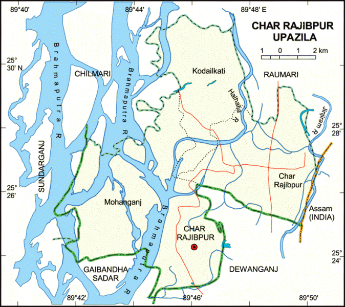
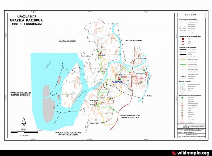
Char Rajibpur Upazila (Kurigram district) with an area of 111.03 sq km, is bounded by Raumari and Chilmari upazilas and Brahmaputra river on the north, Dewanganj and Gaibandha sadar upazilas and Brahmaputra river on the south, Kuchbihar District and Assam state of India on the east, Sundarganj upazila on the west. Noted rivers: Brahmaputra, Halhali and Jinjiram.
Char Rajibpur is located at 25.4000°N 89.6917°E. It has 11,124 households. Rajibpur (Town) consists of one mouza. It has an area of 9.13 sq km. The town has a population of 8655; male 51.06% and female 48.94%; density of population is 948 per sq km. Literacy rate among the town people is 21%. The town has one dakbungalow.
Rajibpur thana, now an upazila, was established in 1977. The upazila consists of 3 union parishads, 26 mouzas and 72 villages.
As of the 1991 Bangladesh census, Population 58049: male 49.54%, female 50.46%; Muslim 99.51%; Hindu 0.49%.
Religious institutions Mosque 110.
Average literacy 16.4%; male 23%, female 9.9%. Educational institutions: college 1, high school 8, madrasa 14, government primary school 21, non-government primary school 33. Noted educational institutions: Rajibpur High School, Char Newasi High School and Rajibpur College.
Main occupations Agriculture 50.57%, agricultural labourer 30.27%, wage labourer 1.55%, commerce 3.93%, service 2.62% and others 11.06%.
Land use Total cultivable land 6279.64 hectares, fallow land 159.85 hectares; single crop 20%, double crop 52% and treble crop 28%; land under irrigation 30%.
Land control Among the peasants 11% are landless, 12.5% marginal, 44.5% small, 20% intermediate and 12% rich; cultivable land per head 0.07 hectare.
Fisheries, dairies and poultries Dairy 92 and poultry 4.
Manufactories Rice and flour mill 7, welding 5.
Cottage industries: Bamboo and cane work 30, goldsmith 10, blacksmith 20, potteries 22, wood work 12, tailoring 20.
Communication facilities Roads: pucca 4 km, semi pucca 7 km and mud road 200 km; waterways 14 nautical mile.
Health centres: Upazila health complex 1, family planning centre 1, veterinary hospital 1, TB and leprosy clinic 1.
NGO activities Operationally important NGOs are brac, asa, RDRS.
Nearby cities:
Coordinates: 25°26'37"N 89°47'44"E
- Shaghatta Upazila 39 km
- Gobindaganj Upazila 64 km
- Sarishabari Upazila 68 km
- Bholahat Upazila HQ 170 km
- Abhaynagar Upazila HQ 269 km
- Fakirhat Upazila HQ 294 km
- Kachua Upazila HQ 308 km
- Koyra Upzila HQ 345 km
- Maidi Vdc 573 km
- Samote Union Council 1812 km
- Thawlynhlong 9 km
- Sanandar Haat 9 km
- Hatebhanga 18 km
- Gaibandha District 32 km
- Jamalpur District 35 km
- Garo Hills in Jhenaigati and Nalitabari, Bangladesh 36 km
- Kurigram District 38 km
- Sherpur District 49 km
- Rajshahi Division 88 km
- Dhaka Division 155 km
Comments