Point Bonita Lighthouse
USA /
California /
Sausalito /
World
/ USA
/ California
/ Sausalito
World / United States / California
lighthouse, historic landmark


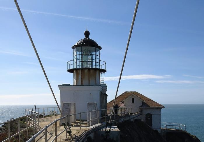

The original Point Bonita Lighthouse, a 56-foot brick tower, was located too high. Unlike the East Coast of the United States, the West Coast has dense high fog, which leaves lower elevations clear. The original light was 306 feet above sea level so the second order Fresnel lens was often cloaked in fog and could not be seen from the sea. In 1877, the lighthouse was moved to its current location at 124 feet above sea level. The United States Coast Guard currently maintains the light and fog signal. It is accessible to the public during limited hours on Sundays, Mondays, and Saturdays.
www.nps.gov/goga/pobo.htm
www.lighthousefriends.com/light.asp?ID=76
www.nps.gov/goga/pobo.htm
www.lighthousefriends.com/light.asp?ID=76
Wikipedia article: http://en.wikipedia.org/wiki/Point_Bonita_Lighthouse
Nearby cities:
Coordinates: 37°48'56"N 122°31'46"W
- Santa Cruz (Gull Island) Aid to Navigation 494 km
- Lantern Point 678 km
- Heceta Head Lighthouse, Devils Elbow State Park 717 km
- Merry Island 1302 km
- Beacon Hill 1400 km
- Lake Minatare State Recreation Area and Historic Lake Minatare Lighthouse 1684 km
- Playa de la Isla de la Piedra 2238 km
- Smoky Point Lighthouse 3370 km
- USCG Molokai Light 3783 km
- USCG La’au Point 3818 km
- Point Bonita 0.4 km
- San Francisco Main Ship Channel 1.8 km
- Fort Barry 1.9 km
- Golden Gate 2.5 km
- Fort Cronkhite 3.1 km
- Tennessee Valley / Tennessee Cove 3.6 km
- Potato Patch Shoal 4.5 km
- Muir Beach, California 6.8 km
- Richardson Bay 7 km
- San Francisco Bay 25 km