Petroglyph National Monument (Albuquerque, New Mexico)
USA /
New Mexico /
Los Ranchos de Albuquerque /
Albuquerque, New Mexico
World
/ USA
/ New Mexico
/ Los Ranchos de Albuquerque
World / United States / New Mexico
petroglyph, interesting place, national park

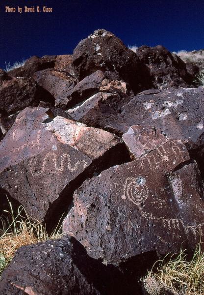
Rock drawings dating back to 1300 AD.Panoramic image is taken from the hilltop looking toward the East, overlooking the Ladera neighborhood and Albuquerque in the distance.
www.nps.gov/petr/
www.nps.gov/petr/
Wikipedia article: http://en.wikipedia.org/wiki/Petroglyph_National_Monument
Nearby cities:
Coordinates: 35°8'24"N 106°44'19"W
- Petroglyph National Monument 4.5 km
- Historic Atrisco Land Grant 20 km
- Kasha-Katuwe Tent Rocks National Monument 65 km
- Sagebrush Flats 91 km
- Valley of Fires Lava Flow (Carrizozo Malpais) 152 km
- Two Peaks - Carson Estates 173 km
- Bitter Lake National Wildlife Refuge 279 km
- Mescalero Sands 321 km
- Rabbit Ear Mountain 351 km
- Carlsbad Caverns National Park 379 km
- Paseo de la Mesa Open Space 2.1 km
- Ladera 3.4 km
- Taylor Ranch 5 km
- Double Eagle II Airport (KAEG) 5.5 km
- Soils Amendment Facility 8.5 km
- Atrisco 8.8 km
- Westgate 9 km
- Albuquerque Shooting Range Park 10 km
- The Weed Field 11 km
- South Valley, New Mexico 14 km