Psathoura
Greece /
Magnisia /
Patitirion /
World
/ Greece
/ Magnisia
/ Patitirion
, 49 km from center (Πατητήριον)
World / Greece / Kentriki Makedonia
volcano, extinct volcano, uninhabited island

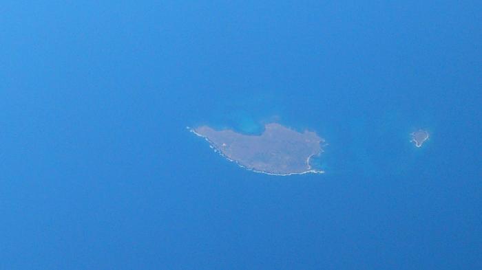
Formed by Sporades volcano of miocene-pleistocene age.Psathoura (Greek: Ψαθούρα) is a Greek island in the Northern Sporades. It is administratively a part of Alonnisos. As of 2011, it had no resident population. The Psathoura lighthouse, built in 1895, stands at 28.9 metres. It is one of the tallest in the Aegean. Its signal is a flash of one second every ten seconds. All of Psathoura is in Zone A2 of the Alonnisos Marine Park. Its nearest islands and islets are Pelagos to the southwest, Gioura to the south and Piperi to the southeast.
www.greece.com/destinations/Sporades/Alonissos/Island/P...
alonnisos.net/en/alonnisos/article/psathoura
www.angelfire.com/super2/greece/psathoura.html
volcano.si.edu/volcano.cfm?vn=212800
www.greece.com/destinations/Sporades/Alonissos/Island/P...
alonnisos.net/en/alonnisos/article/psathoura
www.angelfire.com/super2/greece/psathoura.html
volcano.si.edu/volcano.cfm?vn=212800
Wikipedia article: http://en.wikipedia.org/wiki/Psathoura
Nearby cities:
Coordinates: 39°29'58"N 24°10'48"E
- Perimeter of Thera before Minoan eruption 351 km
- Karadağ 805 km
- Nemrut volcanic massif 1553 km
- Süphan Mountain 1599 km
- Tendürek Mountain 1678 km
- Ariya Volcanic Field 1739 km
- Siyahgan Volcanic Field 1752 km
- Volcano Region Uweinat - North 1918 km
- Salma caldera 2145 km
- Old Activist Volcano Area 2322 km
- Psathonisi 1.9 km
- Cape Tabouras 7.8 km
- Gioura 12 km
- Meghali Vala 15 km
- Piperi (island) 21 km
- Kyra Panagia 21 km
- National Marine Park of Alonnisos 28 km
- Sporades Islands 43 km
- Peripheral Unit of Magnesia / Peripheral Unit of Northern Sporades 71 km
- Peripheral unit of Chalkidiki 103 km