San Jacinto Mall - Interior (demolished) (Baytown, Texas)
USA /
Texas /
Baytown /
Baytown, Texas
World
/ USA
/ Texas
/ Baytown
World / United States / Texas
historical layer / disappeared object
Add category
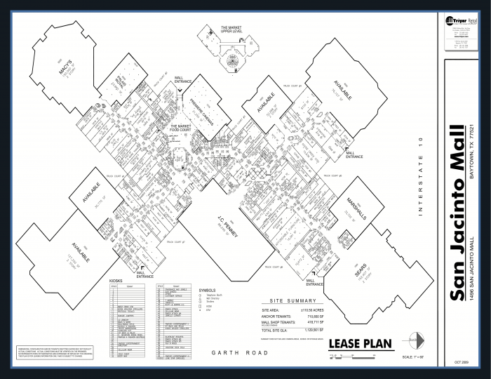
Shown above is a floor plan (at a slight angle) of the mall and its tenants circa 2006. Please do not add pictures of the mall proper in this polygon (see "San Jacinto Mall") nor add the anchors in the outline (that's all ten, including the cinema). The tenant list below reflect some of the last stores to be in the mall at it's closure. The Sears, Mervyn's/Service Merchandise, and Montgomery Wards wings were demolished by 2020 when demolition stalled due to the bankruptcy of JCPenny, one of the two remaining anchor stores who own their buildings and have contracts that require the developer get approval from them to continue redevelopment.
In this building
Click to show deleted objects Deleted objects
- Former Wally's Party Factory
- Coach House Gifts
- Hidden Talent
- Bourbon Street Grill
- Crystal Nails
- Visible Changes
- Morrow's Nut House
- Merle Norman
Nearby cities:
Coordinates: 29°47'57"N 94°59'4"W
- Original Boundaries of Houston's Second Ward 37 km
- Third Ward 39 km
- Fourth Ward 40 km
- Camp Wallace 46 km
- Sabine Free State (Historical) 290 km
- Course of Mississippi River in 1806 343 km
- Former Belle Grove Sugar Plantation 375 km
- Lakeland Gardens Subdivision (Non-Developed) 452 km
- New Basin Canal 470 km
- Original course of Bayou Barataria 471 km
- San Jacinto Marketplace 0.1 km
- Independence Bend 0.6 km
- Baytown Marketplace 0.6 km
- Highland Farms 0.7 km
- Baytown Shops 0.8 km
- Boulevard District 0.8 km
- Second Baptist Church 1.8 km
- Northside 1.9 km
- East End Highland Farms 2 km
- Wayne Gray Sports Complex 2.6 km
Comments