Port Pontchartrain/Milneburg Lighthouse (New Orleans, Louisiana)
| interesting place
USA /
Louisiana /
Arabi /
New Orleans, Louisiana
World
/ USA
/ Louisiana
/ Arabi
World / United States / Louisiana
interesting place
Add category


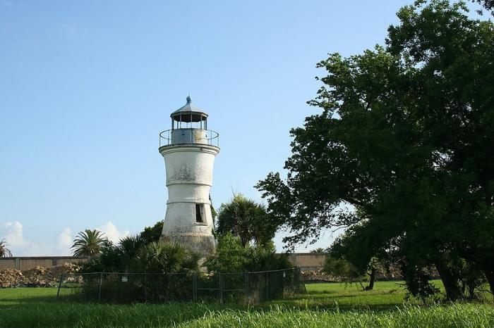

This lighthouse was built in 1855, becoming the third generation lighthouse built on that site. Once 1000 feet out into the water, it is now located inland due to coastal reclamation projects conducted in the early - mid 1900's.
The area was first the site of Port Pontchartrain, founded by Alexander Milne in the 1800's. At some point in its life, it became Milneburg, a small resort town, and it existed until the 1920's. Milneburg is also the focus of a song called "Milenburg Joys," (Milneburg is purposely misspelled) which is still today a jazz standard. Today, Milneburg is a nearby neighborhood to the southeast.
From the 1920's to 1983, this area was Pontchartrain Beach, New Orleans' most famous amusement park. In the park, this lighthouse was a key landmark. Pontchartrain Beach closed in 1983, and does not exist today. The only pieces of this park that are left are the lighthouse, the station house for the Ragin' Cajun roller coaster, and the beach. Today, the lighthouse is inactive.
www.lighthousefriends.com/light.asp?ID=807
Nearby cities:
Coordinates: 30°1'55"N 90°3'43"W
- Village of Jean Lafitte, Louisiana 31 km
- Tickfaw State Park 71 km
- Dulac, Louisiana 90 km
- Duncan Point 120 km
- Cat Island National Wildlife Refuge 162 km
- Tunica Hills WMA 176 km
- Lake Peigneur 186 km
- Camp Claiborne WWII Army Camp 272 km
- Sabine Free State (Historical) 453 km
- Alabama Coushatta Reservation 456 km
- Gentilly 2.7 km
- Filmore 2.8 km
- City Park 4.6 km
- St. Roch 5.6 km
- West Lake Forest 6.8 km
- Little Woods 7.9 km
- New Orleans East 11 km
- Gulf Intracoastal Waterway 11 km
- Central Wetlands 20 km
- Lake Pontchartrain 21 km
Comments