Stalag Luft IV
Poland /
Zachodnio-Pomorskie /
Polczyn-Zdryj /
World
/ Poland
/ Zachodnio-Pomorskie
/ Polczyn-Zdryj
World / Poland / West Pomeranian
historical layer / disappeared object
Add category

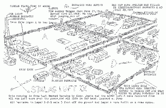

Approximate location of German POW camp during the II World War
Wikipedia article: http://en.wikipedia.org/wiki/Stalag_Luft_IV
Nearby cities:
Coordinates: 53°56'34"N 16°10'30"E
- Relicts of planned Highway (Berlin-Kaliningrad) 27 km
- Brodźce 50 km
- Main combat strip range (Czołgowisko) Borne 50 km
- Przełęg 53 km
- Płytnica 56 km
- Former POW camp Oflag II-D 56 km
- WW II Luftwaffe airfield and hydroplane base 94 km
- Usedom 161 km
- Training site Altranft 193 km
- Battle of Seelow Heights (April 16th-19th, 1945) - WW2 193 km
- Stalag Luft IV 0.1 km
- PKP Wielanowo. 12 km
- Electrical substation 20 km
- Train station 20 km
- ul. Bobolicka, 20 21 km
- Church 24 km
- Świętno 26 km
- school 28 km
- PKP Iwin. 28 km