Phanigiri hill (BUDDHIST REMAINS SITE)
India /
Andhra Pradesh /
Suriapet /
World
/ India
/ Andhra Pradesh
/ Suriapet
World / India / Andhra Pradesh / Nalgonda
archaeological site, heritage, buddhism
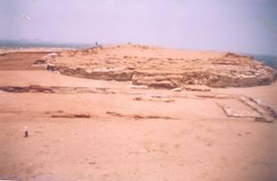

Phanigiri village lies on the left bank ofthe rivulet Aleru, a tributary ofthe river Musi. The Buddhist site is located on hill-top about 150 feet high and is about 35 kms from Suryapet and 11 Okms from Hyderabad via Bhongir and Tirumalagiri. It is just 4kms from Tirumalagiri, the Mandai Headquarters in Nalgonda District. At present, the rivulet Aleru flows 2 kms away from the habitation in north- south direction.
Etymologically, the village Phanigiri seems to have derived its name from the shape of hillock located on the northern side of the village, which looks like a snake hood. In Sanskrit, Phani means snake, Giri means hillock. The water tanks and rock cut cisterns on the hilltop and also tanks at the foot of the hillock not only served as the main water source for the inhabitants but also the rivulet Aleru or Bikkeru, which traversed nearby the monastic complex during the early centuries of Christian Era. It is one of the important Buddhist monasteries strategically located on the hill top, on ancient trade route connecting the west and the east Coast off the Deccan.
the details are from archeology website
Nearby cities:
Coordinates: 17°25'39"N 79°28'20"E
- Bhattiprolu 202 km
- Ashoka Rock Edicts (on the hill) 319 km
- GHANI KONDA (also known as Durga konda) 432 km
- GURU BHAKTULA KONDA (Buddhist Monastery Remains) 433 km
- Dantapuram an Ancient City (Dantapuri or Danthavarapukota) 484 km
- Salihundam Hill 493 km
- Ellora Caves 538 km
- Sera Monastery 674 km
- Udaygiri 800 km
- Rahathangala kanda 1205 km
- malipuram 4.1 km
- Tirumalagiri X 5.3 km
- Gundepuri cheruvu 7.2 km
- Velishala Damera Somaiah 7.5 km
- Rudramma Cheruvu, Velugupally 10 km
- KASARLAPAHAD {Naveen Etikala's home} 12 km
- Arvapally gutta 13 km
- vempati cheruvu 14 km
- Venkepally & Sangem Lake 19 km
- KODURU KONDA(GUTTA) 20 km