Location of PEPCON explosion (Henderson, Nevada)
USA /
Nevada /
Henderson /
Henderson, Nevada
World
/ USA
/ Nevada
/ Henderson
World / United States / Nevada
factory, explosion site
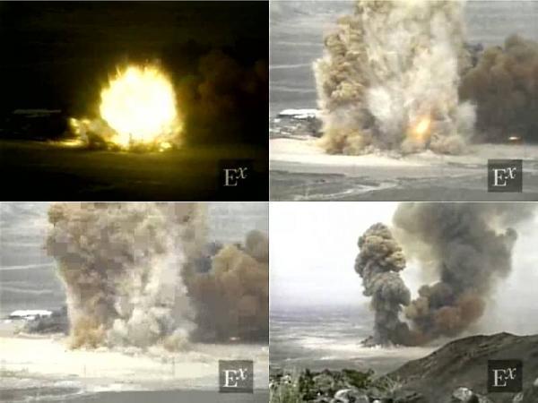
The PEPCON explosion occurred here on May 4, 1988.
The PEPCON plant was one of only two American producers of ammonium perchlorate, an oxidizer used in solid fuel rocket boosters, including the Space Shuttle Solid Rocket Boosters and military weapons. The fire is reported to have originated in or around a drying process structure in the PEPCON plant between 11:30 and 11:40. Employees' attempts to extinguish the fire were unsuccessful, and they abandoned their effort when the first of a series of explosions occurred in the 200 liter (55 gallon) drums.
The first of two major explosions occurred in the drum storage area. The fire continued to spread and reached the storage area for the filled aluminum shipping containers. This resulted in an even larger, second major explosion, about four minutes later. Very little fuel remained after the second explosion and the flame diminished rapidly except for the flame plume created when the high pressure natural gas line beneath the plant was ruptured in one of the explosions. The gas line was shut off at 12:59 hours by the gas company, at a valve about a mile away, eliminating the fuel for this fire.
www.damninteresting.com/?p=800
www.youtube.com/watch?v=HJVOUgCm5Jk
Wikipedia article: http://en.wikipedia.org/wiki/PEPCON_disaster
Nearby cities:
Coordinates: 36°2'27"N 115°1'56"W
- Cemex USA 13 km
- Searles Valley Minerals 215 km
- Mitsubishi Cement Corporation, Cushenbury Plant 250 km
- Colton Portland Cement Plant 305 km
- Texas Industries (TXI) 310 km
- California Steel Industries 314 km
- Palmdale Regional Airport/United States Air Force Plant 42 321 km
- MillerCoors Brewing Facility 340 km
- Dutch Flats Airfield,Site of Ryan Airlines Aircraft Plant (site) 417 km
- Santo Tomas Winery 477 km
- Olin Chlor Alkali chemical plant 1.8 km
- Black Mountain Industrial Complex 2.6 km
- Springfield South Valley Ranch subdivision 4.2 km
- Wastewater treatment plant 5.1 km
- Edward Clark Generating Station 5.5 km
- Heritage at Cadence 6.5 km
- Wetlands Park 6.6 km
- Tuscany Golf Club 7.3 km
- Whitney, Nevada 7.9 km
- Las Vegas, Nevada_duplicate 14 km
Comments