Šilalė district municipality
Lithuania /
Taurages /
Silale /
World
/ Lithuania
/ Taurages
/ Silale
World / Lithuania / Taurages
municipality, invisible, second-level administrative division
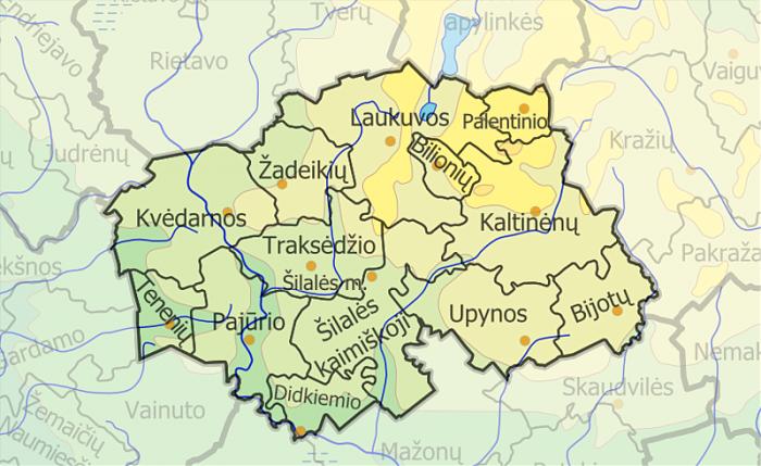
Located in western Lithuania, covers area of 1188 km². Divided into 14 elderships. Administrative centre - Šilalė.
Part of municipality is preserved by Pagramantis, Varniai regional parks. Many rivers, the longest is Jūra. There are many nature and archeological heritage, especially mounds. Medvėgalis is the highest hill in Samogitia (Žemaitija). In Bijotai visitors can see the famous Baublys - the first regional museum, which was established in oak trunk in 19th century. In Laukuva stands the first metheorological rediolocator in state.
Part of municipality is preserved by Pagramantis, Varniai regional parks. Many rivers, the longest is Jūra. There are many nature and archeological heritage, especially mounds. Medvėgalis is the highest hill in Samogitia (Žemaitija). In Bijotai visitors can see the famous Baublys - the first regional museum, which was established in oak trunk in 19th century. In Laukuva stands the first metheorological rediolocator in state.
Wikipedia article: http://en.wikipedia.org/wiki/Šilutė_district_municipality
Nearby cities:
Coordinates: 55°31'30"N 22°13'26"E
- Tauragė district municipality 22 km
- Pagėgiai municipality 44 km
- Rietavas municipality 47 km
- Šilutė district municipality 75 km
- Neringa municipality 81 km
- Neringa 82 km
- Klaipėda district municipality 84 km
- Gmina Puck 270 km
- Gmina Pruszcz Gdański 271 km
- Gmina Koronowo 374 km
- Šilalė rural eldership 6.6 km
- Laukuva eldership 10 km
- Kaltinėnai eldership 15 km
- Pagramantis regional park 16 km
- Mažonai eldership 19 km
- Skaudvilė eldership 24 km
- Žygaičiai eldership 27 km
- Batakiai eldership 27 km
- Kražiai eldership 28 km
- Lower Nemunas plain 72 km