Tauragė district municipality
Lithuania /
Taurages /
Taurage /
World
/ Lithuania
/ Taurages
/ Taurage
World / Lithuania / Taurages
municipality, invisible, second-level administrative division
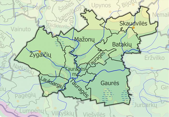
Located in western Lithuania, covers area of 1179 km². Divided into 8 elderships. Administrative centre - Tauragė, smaller city is Skaudvilė.
There are many rivers, the longest are Jūra, Šešuvis, Ežeruona. Southern part is very forested, the biggest forest is Karšuva Forest. Artoji, Plynoji, Laukėsa swamps are one of biggest in the country. Part of municipality area is preserved by Viešvilė state reserve and Pagramantis regional park. Many nature monuments remained. Highway A12 is extended across the municipality.
www.taurage.lt/index.php?265661091
Wikipedia article: http://en.wikipedia.org/wiki/Tauragė_district_municipality
Nearby cities:
Coordinates: 55°17'58"N 22°18'27"E
- Pagėgiai municipality 41 km
- Šilalė district municipality 52 km
- Rietavas municipality 71 km
- Šilutė district municipality 84 km
- Neringa municipality 95 km
- Neringa 95 km
- Klaipėda district municipality 102 km
- Gmina Pruszcz Gdański 266 km
- Gmina Puck 270 km
- Gmina Koronowo 364 km
- Mažonai eldership 6.8 km
- Tauragė eldership 7.4 km
- Pagramantis regional park 11 km
- Batakiai eldership 13 km
- Gaurė eldership 14 km
- Žygaičiai eldership 17 km
- Skaudvilė eldership 21 km
- Jurbarkai eldership 28 km
- Southwest Samogitian moraine plain 30 km
- Lower Nemunas plain 50 km