Black Angel Lead/Zinc Mine
Greenland /
Uummannaq /
Maarmorilik /
World
/ Greenland
/ Uummannaq
/ Maarmorilik
World / Greenland / Kitaa
mine
Add category

Project Overview
The Black Angel mine is on the west coast of Greenland at 51°14'W and 71°7'N.
In the 1920s the Danes began mining marble at Marmorilik in the Uummannaq Fiord. The marble was of as high quality as the best Italian Carrara marble.
In 1936 the son of a miner found a strange glittery stone near the mine, the family kept it as a curiosity and only in the 1960s was it seen by a visiting geologist who was excited to discover that it was high grade sphalerite/galena with a higher concentration of Lead and Zinc than virtually any found elsewhere in the world.
The discovery was followed by exploration that pinpointed the source of the ore to a place across the fiord from the marble quarry, 600m up a sheer cliff and close to a dark shape on the cliff, known to the Inuits for many years as the Black Angel.
By 1973 a simple harbour had been established where an old passenger ship served as lodgings for the miners.
A cable system transported miners and equipment across the fiord to the newly established mine.
The Black Angel mine was born. This was mining at the extremes in one of the most inaccessible places on Earth.
In winter, severe winds stopped the cable car and miners could be marooned in the mine with no food, just some tea, coffee and juice.
The mine operated between 1973 and 1990 during which time nearly 12 million tonnes of ore was extracted from the mine with average grades of 12% Zn and 4 % Pb.
Today
Angel Mining has obtained a licence to mine Black Angel and is planning to re-open the mine. There are also plans to undertake extensive exploration of our 259 km2 licence area aimed at the discovery of other significant zinc/lead deposits, which are known to be present in the area.
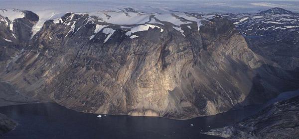
The mine, which is approximately 5 km long, is located inside Black Angel mountain (see photo) and its entrance is on a cliff face 600m above the fjord level (just under the Angel's 'hand').
The old cable car system was removed and we are in the process of installing a new upgraded system for future operations.
See spanning the void, a story about the difficulties of installing the car.
When the mine was closed in 1990 approximately 2 million tonnes of ore were left behind, mainly in the pillars.
Phase One of our operations starts with the extraction of the pillars from the old mine, a complex and difficult operation made more so by the extreme conditions in which we work. We will be guided by Golder Associates, a Canadian-based consultancy who are acknowledged world experts in pillar removal. They undertook the work for the bankable feasibility study which was completed in January 2008.
SGS Mineral Services and GBM, have been appointed to work with us to develop the mineral processing and waste handling plant.
The extraction of the pillars is expected to last for 5 years and will be followed by Phase Two concentrating on the 'new discoveries' near the mine. The total mine life is expected to exceed 20 years based on current geological data.
Tomorrow
The most spectacular discovery on the ground was finding an outcrop of massive sulphide uncovered by a retreating glacier. The existence of mineralisation at this location was known, but previously it was covered by 60m of ice.
Grab samples taken from the outcrop returned 7% Zn and 2.5% Pb and the drilling results from 2006 and 2007 confirmed these grades. We initially believed that the outcrop was 250m long, but closer examination has revealed that the mineralisation on the surface continues for nearly 850m in almost a straight line, the eastern end disappearing under the glacier.
South Lakes Glacier
Contrary to what you might think, the South Lakes Glacier is NOT a river of ice pushing towards the sea with all its might and producing huge icebergs. It is in reality a rather pathetic pile of old snow. We call it a 'pancake glacier' - it doesn't reach sea level, lies on a flat terrain and slowly melts away. It is a lame tentacle of the Greenlandic ice cap where the downhill rate of flow of the ice is exceeded by melting, hence the retreat.
We have established, from aerial photos, that since 1954 it has retreated nearly 850m, of which some 250m happened in the last decade. In its retreat it revealed an outcrop of massive sulphide - zinc and lead mineralisation.
The mineralisation is very distinct, with the sulphides making a brown 'matrix’ in which white marble 'clasts' float. (The darker the colour, the higher the grade).
It appears that the actual outcrop may be in a hinge of a fold eroded by the glacial action. The strata on both sides of the outcrop dip in opposite directions.
Because this structure is complex we invited two structural geologists to the site (in addition to the 3 resident ones) to help us better understand it. We have put 44 drill holes through this prospect and all hit mineralisation. The results demonstrate that the mineralised zone is proved to a depth of 100m thick and opened at depth.
The sulphides form distinct bands of re-mobilised mineralisation, which on the surface measure from 0.2m to 5m. Parts of the outcrop are difficult to see because of the loose material deposited by the glacier.
It is the most promising outcrop of massive sulphides found since the original Black Angel discovery and we hope may indicate the presence of a Zinc Province.
The terrain around the showing is relatively flat so it should be relatively straightforward to create a mine.
Phase Two will exploit these newly discovered deposits, which are 6 km from the existing mine. Because the mineralised zone outcrops we expect that the initial mining activity will be from an open pit.
We also plan to undertake further exploration, which could extend the potential life of the mines still further.
Spanning the Void from Maarmorilik to the Mine in the Cliff Face:
Linking the mine entrance (“adit”) to the ground facilities at Maarmorilik is a substantial engineering challenge. The cable car will have to span 1.7km and it has to rise 600m to the adit which is located on a cliff face made of white marble.
The cable car has been manufactured by Garaventa of Switzerland and is currently on site at Marmorilik. The lower terminal has been constructed with the steel superstructure being added this summer. Work has commenced on the upper terminal but there is still more excavation work required before the rock face can be strengthened with rock bolts and the reinforced concrete structure can be built. This work will be done by Gasser, another specialist Swiss company, together with EMJ, a Greenlandic civil engineering and construction company during the second quarter of next year.
Currently, the only practical way to access the mine is to climb down from the top of the mountain, which is accessed by helicopter. Part of the climb requires abseiling, so this is not an easy way to get machines and materials where they will be needed.
It is therefore planned to install a temporary cable from the adit to Maarmorilik, which will be capable of taking loads of up to 1 tonne which will then be winched across the fjord. Men will still have to access the mine from the top of the mountain and will spend several days at a time living in the mine during a work period.
At low temperatures, concrete takes a long time to cure and the construction team will have to work hard as Garaventa will be aiming to install the main cables before the ice melts in early June. They will not want the cables to come in contact with sea water, so carrying them across the ice is an important part of the installation plan.
Once the cable car is in place, we will then be able to take loads up to 5 tonnes in weight and work will commence to transport mining equipment and the components of the mineral processing plant into the mine. And, if all goes to plan, the first zinc and lead concentrates will be transported by the cable car from the mine to waiting containers at Maarmorilik from where they will be shipped to Europe for smelting into saleable metal.
www.angelmining.com/black-angel
The Black Angel mine is on the west coast of Greenland at 51°14'W and 71°7'N.
In the 1920s the Danes began mining marble at Marmorilik in the Uummannaq Fiord. The marble was of as high quality as the best Italian Carrara marble.
In 1936 the son of a miner found a strange glittery stone near the mine, the family kept it as a curiosity and only in the 1960s was it seen by a visiting geologist who was excited to discover that it was high grade sphalerite/galena with a higher concentration of Lead and Zinc than virtually any found elsewhere in the world.
The discovery was followed by exploration that pinpointed the source of the ore to a place across the fiord from the marble quarry, 600m up a sheer cliff and close to a dark shape on the cliff, known to the Inuits for many years as the Black Angel.
By 1973 a simple harbour had been established where an old passenger ship served as lodgings for the miners.
A cable system transported miners and equipment across the fiord to the newly established mine.
The Black Angel mine was born. This was mining at the extremes in one of the most inaccessible places on Earth.
In winter, severe winds stopped the cable car and miners could be marooned in the mine with no food, just some tea, coffee and juice.
The mine operated between 1973 and 1990 during which time nearly 12 million tonnes of ore was extracted from the mine with average grades of 12% Zn and 4 % Pb.
Today
Angel Mining has obtained a licence to mine Black Angel and is planning to re-open the mine. There are also plans to undertake extensive exploration of our 259 km2 licence area aimed at the discovery of other significant zinc/lead deposits, which are known to be present in the area.
The mine, which is approximately 5 km long, is located inside Black Angel mountain (see photo) and its entrance is on a cliff face 600m above the fjord level (just under the Angel's 'hand').
The old cable car system was removed and we are in the process of installing a new upgraded system for future operations.
See spanning the void, a story about the difficulties of installing the car.
When the mine was closed in 1990 approximately 2 million tonnes of ore were left behind, mainly in the pillars.
Phase One of our operations starts with the extraction of the pillars from the old mine, a complex and difficult operation made more so by the extreme conditions in which we work. We will be guided by Golder Associates, a Canadian-based consultancy who are acknowledged world experts in pillar removal. They undertook the work for the bankable feasibility study which was completed in January 2008.
SGS Mineral Services and GBM, have been appointed to work with us to develop the mineral processing and waste handling plant.
The extraction of the pillars is expected to last for 5 years and will be followed by Phase Two concentrating on the 'new discoveries' near the mine. The total mine life is expected to exceed 20 years based on current geological data.
Tomorrow
The most spectacular discovery on the ground was finding an outcrop of massive sulphide uncovered by a retreating glacier. The existence of mineralisation at this location was known, but previously it was covered by 60m of ice.
Grab samples taken from the outcrop returned 7% Zn and 2.5% Pb and the drilling results from 2006 and 2007 confirmed these grades. We initially believed that the outcrop was 250m long, but closer examination has revealed that the mineralisation on the surface continues for nearly 850m in almost a straight line, the eastern end disappearing under the glacier.
South Lakes Glacier
Contrary to what you might think, the South Lakes Glacier is NOT a river of ice pushing towards the sea with all its might and producing huge icebergs. It is in reality a rather pathetic pile of old snow. We call it a 'pancake glacier' - it doesn't reach sea level, lies on a flat terrain and slowly melts away. It is a lame tentacle of the Greenlandic ice cap where the downhill rate of flow of the ice is exceeded by melting, hence the retreat.
We have established, from aerial photos, that since 1954 it has retreated nearly 850m, of which some 250m happened in the last decade. In its retreat it revealed an outcrop of massive sulphide - zinc and lead mineralisation.
The mineralisation is very distinct, with the sulphides making a brown 'matrix’ in which white marble 'clasts' float. (The darker the colour, the higher the grade).
It appears that the actual outcrop may be in a hinge of a fold eroded by the glacial action. The strata on both sides of the outcrop dip in opposite directions.
Because this structure is complex we invited two structural geologists to the site (in addition to the 3 resident ones) to help us better understand it. We have put 44 drill holes through this prospect and all hit mineralisation. The results demonstrate that the mineralised zone is proved to a depth of 100m thick and opened at depth.
The sulphides form distinct bands of re-mobilised mineralisation, which on the surface measure from 0.2m to 5m. Parts of the outcrop are difficult to see because of the loose material deposited by the glacier.
It is the most promising outcrop of massive sulphides found since the original Black Angel discovery and we hope may indicate the presence of a Zinc Province.
The terrain around the showing is relatively flat so it should be relatively straightforward to create a mine.
Phase Two will exploit these newly discovered deposits, which are 6 km from the existing mine. Because the mineralised zone outcrops we expect that the initial mining activity will be from an open pit.
We also plan to undertake further exploration, which could extend the potential life of the mines still further.
Spanning the Void from Maarmorilik to the Mine in the Cliff Face:
Linking the mine entrance (“adit”) to the ground facilities at Maarmorilik is a substantial engineering challenge. The cable car will have to span 1.7km and it has to rise 600m to the adit which is located on a cliff face made of white marble.
The cable car has been manufactured by Garaventa of Switzerland and is currently on site at Marmorilik. The lower terminal has been constructed with the steel superstructure being added this summer. Work has commenced on the upper terminal but there is still more excavation work required before the rock face can be strengthened with rock bolts and the reinforced concrete structure can be built. This work will be done by Gasser, another specialist Swiss company, together with EMJ, a Greenlandic civil engineering and construction company during the second quarter of next year.
Currently, the only practical way to access the mine is to climb down from the top of the mountain, which is accessed by helicopter. Part of the climb requires abseiling, so this is not an easy way to get machines and materials where they will be needed.
It is therefore planned to install a temporary cable from the adit to Maarmorilik, which will be capable of taking loads of up to 1 tonne which will then be winched across the fjord. Men will still have to access the mine from the top of the mountain and will spend several days at a time living in the mine during a work period.
At low temperatures, concrete takes a long time to cure and the construction team will have to work hard as Garaventa will be aiming to install the main cables before the ice melts in early June. They will not want the cables to come in contact with sea water, so carrying them across the ice is an important part of the installation plan.
Once the cable car is in place, we will then be able to take loads up to 5 tonnes in weight and work will commence to transport mining equipment and the components of the mineral processing plant into the mine. And, if all goes to plan, the first zinc and lead concentrates will be transported by the cable car from the mine to waiting containers at Maarmorilik from where they will be shipped to Europe for smelting into saleable metal.
www.angelmining.com/black-angel
Nearby cities:
Coordinates: 71°7'34"N 51°14'51"W
- Depoosit 1 Initial Bulk Sample Pit 994 km
- Mary River Iron Ore Project Deposit1 994 km
- Mary River Iron Ore Project - Deposit No.1 Lease 994 km
- Nanisivik Mine 1144 km
- Nanisivik Lead/Zinc Mine 1145 km
- Appat Island 33 km
- Illorsuit Island 88 km
- Innerit Peninsula 173 km
- Donjonskirt (Skaluy) Island 175 km
- Qeqertaq Island 191 km
- Kigatak Island 194 km
- Kangeq Peninsula 198 km
- Tukingasoq Island 200 km
- Satoq Island 205 km
- Akia Island 248 km