Zurich, California
USA /
California /
Big Pine /
World
/ USA
/ California
/ Big Pine
World / United States / California
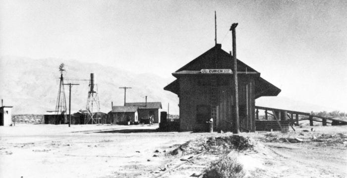
train station, ghost village


Originally named Alvord, the name was changed to Zurich in 1913. Zurich was the first town south of Laws, CA on the ex-Carson & Colorado narrow gauge railroad (later the Southern Pacific Railroad narrow gauge Owens Valley Branch), which originally ran from Mound House, NV to Keeler, CA. After standard gauging of the northern section to Mina, NV and abandonment of the line over Montgomery Pass only the line from Laws, CA to Keeler remained (finally abandoned in 1960). There was a small settlement once located here was gone by 1947.
The town died when the rails were pulled up from Tonopah, NN to Keeler, CA. Named by the residents because the sharp jagged peaks of the White Mountains, located just east of the town and the Sierras to the west looked like the Alps in winter when covered by snow. The last resident was a family who's daughter Josephine (the last person born in Zurich) married a railroad conductor and moved to Mojave, CA. Now 74 in 2000, She still resides in Mojave today.
It had a 20x46 depot built in 1888. The station agency closed in 1932, and the depot razed in 1947. Some foundations and other signs of the buildings once there are all that's left now. The picture shows the rails running through Zurich being removed for scrapping and reused during WWII.
Wikipedia article: http://en.wikipedia.org/wiki/Zurich,_California
Nearby cities:
Coordinates: 37°10'58"N 118°15'42"W
- Bodie State Historic Park 134 km
- Tammukan, California 292 km
- Alum Rock Park 317 km
- Barclay, Nevada 354 km
- Palisades del Rey (Surfridge Ghost Town) 360 km
- China Camp State Park 386 km
- McGill, Nevada 392 km
- Wolf Hole, Arizona 419 km
- Kaiser Mine and Ghost Town 439 km
- Bombay Beach, California 483 km
- Big Pine, California 3.3 km
- Wilkerson, California 15 km
- Poleta Folds 17 km
- Eastern Sierra Regional Airport (BIH/KBIH) 23 km
- Bishop Paiute Reservation 25 km
- Ancient Bristlecone Pine Forest 27 km
- Inyo National Forest 32 km
- Inyo National Forest 37 km
- Kings Canyon National Park 46 km
- White Mountains 48 km