Cement (site)
USA /
California /
Suisun City /
World
/ USA
/ California
/ Suisun City
World / United States / California
interesting place, ghost town
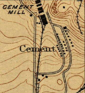
The manufacture of portland cement began in 1902 at the plant of Pacific Portland Cement Company at Cement, about 3 miles northeast of Fairfield. For a few years the supply of limestone for the plant came from travertine deposits near the plant, but as these were being used up rapidly, with increased plant capacity, it became necessary to bring limestone by rail from the company’s Mountain quarries near Cool, El Dorado County. The latter deposits supplied most of the limestone used at the plant from 1910 until 1927, when the cement plant was closed down and dismantled.
The major use of the travertine was in making cement; however, it was used prior to 1900 for smelter flux at Selby lead smelter, and for road metal and concrete aggregate.
Today, the extensive ruins of the former cement mill remain including the company ranch buildings where livestock were raised for meat and eggs; the short line railroad trestle supports and grade; and the rock crusher foundation known locally as The Castle. The site of the Cement company town has been partially redeveloped. Clay Bank Road now runs over what was once Front Street, reserved for company officials, foremen, and their families. Half of Back Street, where the workers and their families lived, is located on the east side of Clay Bank Road where it curves west. A large foundation, possibly that of the three-story Golden Gate Hotel, is located at this point. Facilities that used to be located in town included a hospital, bar, livery stable, post office, telephone exchange, park, baseball diamond, general store, and grade school. Two of the company homes were relocated to 512 and 518 Davis Street in downtown Vacaville after the Cement property was shut down and auctioned off.
www.solanohistorycenter.org/multimedia/videos/channel-5...
www.solanohistorycenter.org/assets/Uploads/pdfs/MapOfCe...
quarriesandbeyond.org/states/ca/quarry_photo/ca-solano_...
www.ghosttowns.com/states/ca/cement.html
Nearby cities:
Coordinates: 38°17'38"N 122°0'20"W
- China Camp State Park 54 km
- Tammukan, California 72 km
- Alum Rock Park 100 km
- Bodie State Historic Park 261 km
- Palisades del Rey (Surfridge Ghost Town) 579 km
- McGill, Nevada 637 km
- Barclay, Nevada 683 km
- Kaiser Mine and Ghost Town 757 km
- Wolf Hole, Arizona 763 km
- Bombay Beach, California 787 km
- Seeno Homes 0.7 km
- Paradise Valley Golf Course 1.9 km
- Cherry Glen Park - Lagoon Valley Park 4 km
- Hillborn 4.3 km
- Rancho Solano Golf Course 6.2 km
- Brazelton Ranch 9 km
- Ephlin Hill 10 km
- Okell Hill 11 km
- Lake Curry 13 km
- Twin Sisters 14 km
Comments