Dyea, AK
USA /
Alaska /
Skagway /
World
/ USA
/ Alaska
/ Skagway
World / Canada / British Columbia / Stikine
place with historical importance, invisible

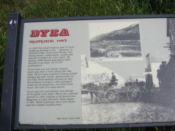


Dyea is a former town in Skagway Borough, Alaska. It is located at the convergence of the Taiya River and Taiya Inlet on the south side of the Chilkoot Pass.
Dyea was a Boom-town during the 1898 Yukon Klondike Gold Rush, serving as a staging point for prospectors traveling on the Chilkoot trail to Dawson.
Nothing remains of the former town today except for scraps of wood on the ground, though a few people live on small homesteads in the valley.
See also:
explorenorth.com/alaska/dyea.html
www.postalmuseum.si.edu/gold/skagdyea.html
en.wikipedia.org/wiki/Chilkoot_Trail_tramways
Wikipedia article: http://en.wikipedia.org/wiki/Dyea,_Alaska
Nearby cities:
Coordinates: 59°30'0"N 135°21'26"W
- Chilkoot Pass 23 km
- Klondike Gold Rush National Historical Park (Skagway Unit) 23 km
- Porcupine Creek Gold Mining Area 53 km
- Pleasant Camp 57 km
- Glacier Bay National Park and Preserve 145 km
- Kluane National Park 242 km
- New Russia Site 253 km
- Sitka National Historical Park 272 km
- Japonski Island 272 km
- Wrangell-Saint Elias National Park and Preserve 648 km
- Taiya Inlet 15 km
- Haines, AK 31 km
- Chilkoot Inlet 34 km
- Chilkat Inlet 39 km
- Sullivan Island 59 km
- Bennett Lake 62 km
- Margerie Glacier 118 km
- Windy Craggy Deposit 137 km
- Fairweather Glacier 147 km
- Ridge 160 km