Hauser Dam
USA /
Montana /
Helena Valley Southeast /
World
/ USA
/ Montana
/ Helena Valley Southeast
World / United States / Montana
dam
Add category


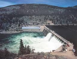
Hauser Dam (also known as Hauser Lake Dam) is a hydroelectric straight gravity dam on the Missouri River about 14 miles (23 km) northeast of Helena, Montana
Wikipedia article: http://en.wikipedia.org/wiki/Hauser_Dam
Nearby cities:
Coordinates: 46°45'53"N 111°53'14"W
- Fort Peck Dam 431 km
- Qu'Appelle Dam 616 km
- Gardiner Dam 621 km
- Homstake Mining Company Tailings Impoundment 689 km
- Garrison Dam 795 km
- Oahe Dam 928 km
- Fort Randall Dam 1126 km
- Virginia Smith Dam 1146 km
- Coon Rapids Dam Regional Park (Anoka County) 1444 km
- Lock and Dam No. 12 1769 km
- Electrical substation 0.2 km
- Black Sandy State Park 2 km
- Sandy White Campground 2.7 km
- Causway Chalet Bar 6.1 km
- 4MT5 Port Smith Heliport 8.2 km
- Hauser Lake 8.4 km
- York Bridge 8.5 km
- Lake Helena 8.5 km
- Holter Lake 15 km