Khtzkonk monastery
Armenia /
Armavir /
Aragats /
World
/ Armenia
/ Armavir
/ Aragats
World / Turkey / Kars
ruins, place with historical importance, archeological site, monastery, destroyed, draw only border, Armenian Apostolic church


KHTZKONK
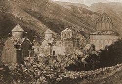
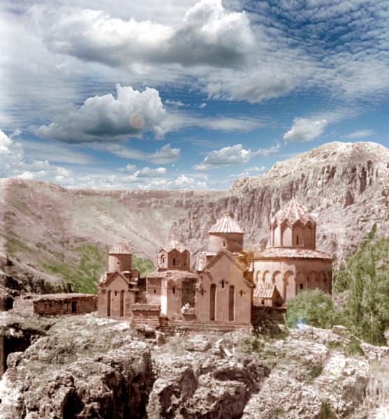
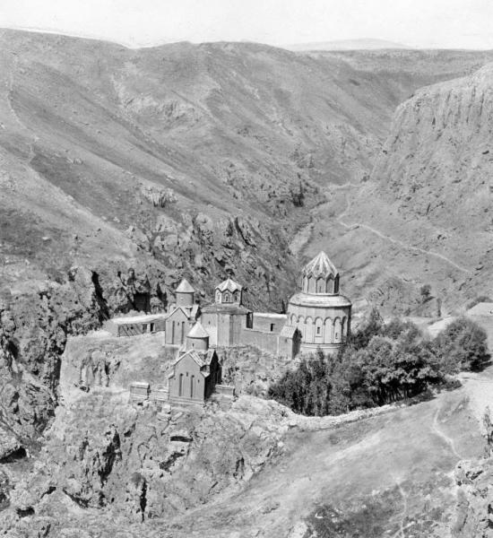
(Arm: ԽԾԿՈՆՔ) is medieval Armenian monastic complex of 5 churches in Western Armenia.
The fate of Khtzkonk is one of the clearest and most disturbing examples of the Turkish state's genocide of this region's Armenian population being later extended to their cultural monuments.
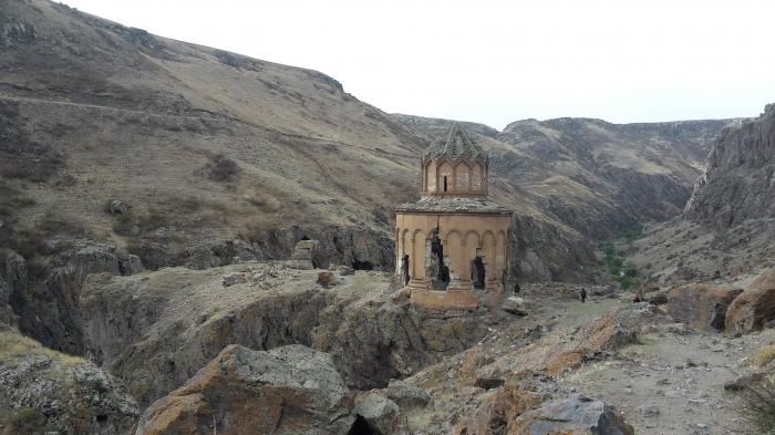
The monastery remained in use until 1920, when the remaining Armenian population of the Kars region was expelled by the Turks. After this, the area became a restricted military zone that was closed to visitors (as late as 1984 a special permit was needed to travel to Digor). When the monastery was next visited by historians, in 1959, only one church, Saint Sargis, remained standing - and it was seriously damaged. It was reported that villagers at that time said the churches had been blown up by Turkish soldiers. The inhabitants of nearby Digor still (2002) say the same thing.
Destruction was caused by explosives. Lumps of masonry from the destroyed churches have been flung far from their original positions. The slopes between the spurs are filled with shattered fragments of stonework, chunks of inscription covered wall, fragments of columns, and bits of ornate sculpture. The damage to the St. Sargis church is even more indicative - the side walls of the apses and chapels have been blown outwards, evidently by explosives placed within them.
Some western academics, not wanting to upset Turkey and thus damage their career advancement, try to wriggle out of explaining Khtzkonk's destruction by inventing alternative reasons for the damage. For example, T. A. Sinclair in his 1987 book "Eastern Turkey, an Architectural and Archaeological Survey" wrote that the churches were destroyed by falling rocks..
- From where did these rocks fall?
- To where did these rocks disappear?
- And how did they manage to defy the laws of gravity by jumping over the Saint Sargis church in order to destroy its neighbours?...
These questions remain unanswered...
Till the date, non of 4 thousands (according to Armenian Patriarchate of Istanbul data) Armenian monasteries existed in pre-genocide East Anatolia / West Armenia are listed in UNESCO's "World Heritage Objects List". Sad reality is, Armenians and their heritage are invisible to the deaf and selfish world, and weak-willed humanity awaiting for the fate of Armenians in its long way of understanding their pain.
Links: virtualani.org/khtzkonk/index.htm
(Arm: ԽԾԿՈՆՔ) is medieval Armenian monastic complex of 5 churches in Western Armenia.
The fate of Khtzkonk is one of the clearest and most disturbing examples of the Turkish state's genocide of this region's Armenian population being later extended to their cultural monuments.
The monastery remained in use until 1920, when the remaining Armenian population of the Kars region was expelled by the Turks. After this, the area became a restricted military zone that was closed to visitors (as late as 1984 a special permit was needed to travel to Digor). When the monastery was next visited by historians, in 1959, only one church, Saint Sargis, remained standing - and it was seriously damaged. It was reported that villagers at that time said the churches had been blown up by Turkish soldiers. The inhabitants of nearby Digor still (2002) say the same thing.
Destruction was caused by explosives. Lumps of masonry from the destroyed churches have been flung far from their original positions. The slopes between the spurs are filled with shattered fragments of stonework, chunks of inscription covered wall, fragments of columns, and bits of ornate sculpture. The damage to the St. Sargis church is even more indicative - the side walls of the apses and chapels have been blown outwards, evidently by explosives placed within them.
Some western academics, not wanting to upset Turkey and thus damage their career advancement, try to wriggle out of explaining Khtzkonk's destruction by inventing alternative reasons for the damage. For example, T. A. Sinclair in his 1987 book "Eastern Turkey, an Architectural and Archaeological Survey" wrote that the churches were destroyed by falling rocks..
- From where did these rocks fall?
- To where did these rocks disappear?
- And how did they manage to defy the laws of gravity by jumping over the Saint Sargis church in order to destroy its neighbours?...
These questions remain unanswered...
Till the date, non of 4 thousands (according to Armenian Patriarchate of Istanbul data) Armenian monasteries existed in pre-genocide East Anatolia / West Armenia are listed in UNESCO's "World Heritage Objects List". Sad reality is, Armenians and their heritage are invisible to the deaf and selfish world, and weak-willed humanity awaiting for the fate of Armenians in its long way of understanding their pain.
Links: virtualani.org/khtzkonk/index.htm
Wikipedia article: http://en.wikipedia.org/wiki/Khtzkonk_Monastery
Nearby cities:
Coordinates: 40°22'50"N 43°22'36"E
- Horomos monastic complex 26 km
- Mother See of Holy Etchmiadzin 81 km
- Church Kamrak Vank ( St.Thomas) 223 km
- Mor Gabriel Monastery 376 km
- بحيرة لاريسا 752 km
- Zelve Open-Air Museum 755 km
- Deir Tamish 993 km
- Monastery of Saint Isaiah (Mar Chaaya) 995 km
- Deir-el-Salib (Monastery of the Cross) 998 km
- Deir an-Nasrani 1049 km
- Armenian basilica of Surb Yerrordutyun 3.3 km
- Digor District 9 km
- Yarlıca (2961 m) 11 km
- Dumanli Mountain (Arjo Aruch) 13 km
- Keshishkiran 16 km
- Ruins 17 km
- Turkish border outpost 18 km
- Ani region 38 km
- Kars Province 40 km
- Talin District 41 km