Kars Province
Turkey /
Kars /
World
/ Turkey
/ Kars
/ Kars
World / Turkey / Kars
province, first-level administrative division, draw only border


Kars Province (Armenian: Կարսի նահանգ; Turkish: Kars ili) is a province of Turkey, located in the northeastern part of the country. It shares part of its border with the Republic of Armenia.
The provinces of Ardahan and Iğdır were until the 1990s part of Kars Province. Mainly corresponds to Vanand district of greater Ayrarat province of Historical Armenia.
The province has a population of 301,766. The population is mostly azeri. There are kurdish people living in the south.
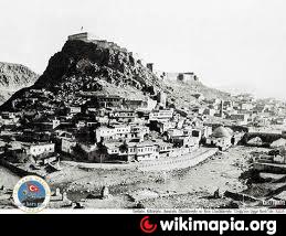
In ancient times, Kars (Armenian:Կարս) was part of the province of Ararat in the Kingdom of Armenia. The first known people were the followers of Vanand (Վանանդ), for whom Kars was their main settlement and fortress. In 928, Kars became the capital of Armenia. In 968, the capital of Armenia was moved to Ani (Անի), but Kars remained the capital of the feudal principality of Vanand. From the 9th to 13th century, even during the Mongol invasion, Kars made significant progress, and the very famous (Առանիկ-Aranik) fortress was completed. Kars, along with many other medieval Armenian towns, began as a fortress, and Armenian historians have referred to such places as berd karouts (-բերդ կարուց). Roughly translated, this means "fortification building". Up until the 13th century, the fortress surrounded the city, and this area was later turned into a citadel. Later on, during the rule of the Persian Empire and the Ottoman Empire, the fortress of Kars, located in what was then the eastern part of the city, fell into disrepair. However, as Kars was within a border region its defensive structures were often renewed, and they continued to advance to such a degree, that in the 19th century Kars was well known around the world as a castle.
As a result of the Russo-Turkish War of 1877 to 1878, the province of Kars was incorporated into the Russian Empire as part of the militarily admqinistered Kars Oblast and remained so until 1918. It was seen as a border province of a Russian Empire which was seeking to expand yet further by the conquest of more territory belonging to the Ottoman Empire. The period from 1878 to 1918 was marked in the province of Kars by the settlement by the Russian authorities of a very heterogeneous mix of Christian populations, including Armenians, Caucasus Greeks, Russians, Georgians, and even smaller numbers from other Christian communities hitherto with little or no historical links to the region, such as ethnic Germans, Poles, Estonians, Lithuanians, and Russian sectarian communities such as Molokans and Doukhobors. Many from the non-Russian Christian Orthodox communities (Georgians, Caucasus Greeks, and the minority of Armenians who were Greek Orthodox) had themselves fought in or collaborated with the Russian Imperial army to capture Kars province from the Muslim Ottomans. They saw this as a means of fulfilling their own ambitions to recapture Christian territory on the back of the Russian imperial enterprise.
The provinces of Ardahan and Iğdır were until the 1990s part of Kars Province. Mainly corresponds to Vanand district of greater Ayrarat province of Historical Armenia.
The province has a population of 301,766. The population is mostly azeri. There are kurdish people living in the south.
In ancient times, Kars (Armenian:Կարս) was part of the province of Ararat in the Kingdom of Armenia. The first known people were the followers of Vanand (Վանանդ), for whom Kars was their main settlement and fortress. In 928, Kars became the capital of Armenia. In 968, the capital of Armenia was moved to Ani (Անի), but Kars remained the capital of the feudal principality of Vanand. From the 9th to 13th century, even during the Mongol invasion, Kars made significant progress, and the very famous (Առանիկ-Aranik) fortress was completed. Kars, along with many other medieval Armenian towns, began as a fortress, and Armenian historians have referred to such places as berd karouts (-բերդ կարուց). Roughly translated, this means "fortification building". Up until the 13th century, the fortress surrounded the city, and this area was later turned into a citadel. Later on, during the rule of the Persian Empire and the Ottoman Empire, the fortress of Kars, located in what was then the eastern part of the city, fell into disrepair. However, as Kars was within a border region its defensive structures were often renewed, and they continued to advance to such a degree, that in the 19th century Kars was well known around the world as a castle.
As a result of the Russo-Turkish War of 1877 to 1878, the province of Kars was incorporated into the Russian Empire as part of the militarily admqinistered Kars Oblast and remained so until 1918. It was seen as a border province of a Russian Empire which was seeking to expand yet further by the conquest of more territory belonging to the Ottoman Empire. The period from 1878 to 1918 was marked in the province of Kars by the settlement by the Russian authorities of a very heterogeneous mix of Christian populations, including Armenians, Caucasus Greeks, Russians, Georgians, and even smaller numbers from other Christian communities hitherto with little or no historical links to the region, such as ethnic Germans, Poles, Estonians, Lithuanians, and Russian sectarian communities such as Molokans and Doukhobors. Many from the non-Russian Christian Orthodox communities (Georgians, Caucasus Greeks, and the minority of Armenians who were Greek Orthodox) had themselves fought in or collaborated with the Russian Imperial army to capture Kars province from the Muslim Ottomans. They saw this as a means of fulfilling their own ambitions to recapture Christian territory on the back of the Russian imperial enterprise.
Wikipedia article: http://en.wikipedia.org/wiki/Kars_Province
Nearby cities:
Coordinates: 40°30'44"N 42°56'24"E
- Northern Borders Region 1035 km
- Kerman Province 1394 km
- Riyadh Province 1489 km
- Balochistan Province 1857 km
- Punjab Province 2439 km
- Mahajanga Province 6053 km
- Toliara Province 6534 km
- East Kalimantan 8079 km
- Saskatchewan 8577 km
- Papua 10272 km
- Cemetery 3.1 km
- Cemetery 3.5 km
- Cemetery 4.3 km
- Cemetery 5.2 km
- Kumbet Church Ruins 8.7 km
- Electrical sub-station 11 km
Comments