Shadullapur Upazlia HQ
Bangladesh /
Gaybanda /
World
/ Bangladesh
/ Gaybanda
/ Gaybanda
World / Bangladesh / Rajshahi / Ranpur / Gaibanda
township, fourth-level administrative division, local government
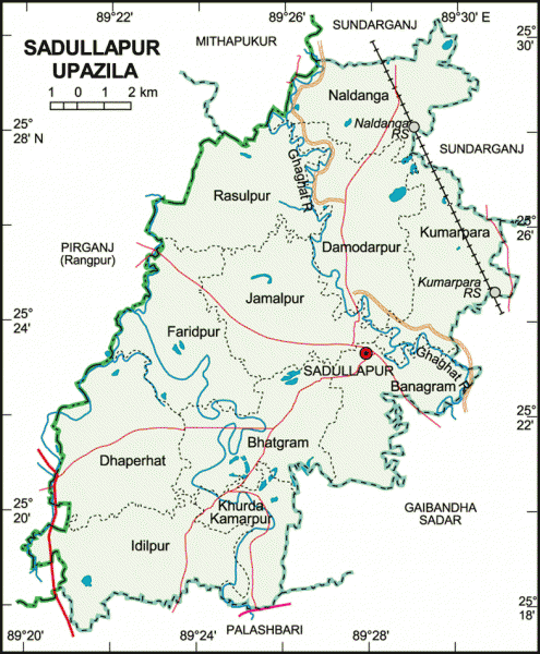
Sadullapur Upazila (Gaibandha district) with an area of 227.97 sq km, is bounded by Sundarganj and Mithapukur upazilas on the north, Palashbari and Gaibandha sadar upazilas on the south, Gaibandha Sadar and Sundarganj upazilas on the east, Pirganj (Rangpur) upazila on the west. This Upazila consists of Barind tract and Tista alluvial soil; Ghaghat is the main river.
The location of Sadullapur town is 25.3862818N 89.4688487E. Sadullapur (Town) consists of four mouzas. The area of the town is 6.38 sq km. It has a population of 10461; male 50.71% and female 49.29%; population density per sq km 1640. Literacy rate among the town people is 33.2%. The town has one dakbungalow.
Sadullapur thana, now an upazila, was established in 1857. The upazila consists of 11 union parishads, 166 mouzas and 172 villages.
As of the 1991 Bangladesh census, Population 243012; male 50.4%, female 49.6%; Muslim 90.05%, Hindu 9.65%, Christian 0.02%, Buddhist 0.03% and others 0.25%.
Religious institutions Mosque 448, temple 32.
Literacy and educational institutions Average literacy 33.4%; male 42.5% and female 25.7%. Educational institutions: college 8, secondary school 48, junior school 5, madrasa 91, government primary school 90, non-government primary school 105, satellite school 10, KG school 2, community school 8. Noted educational institutions: Faridpur Government Primary School (1860), Molong Bazar Government Primary School (1884), Khurdo Komorpur High School (1915), Sadullapur Multilateral Pilot High School (1918), Naldanga Umesh Chandra High School (1946).
Main occupations Agriculture 47.97%, agricultural labourer 28.52%, wage labourer 2.75%, commerce 8.08%, service 3.29% and others 9.39%.
Land use Total cultivable land 18345 hectares, fallow land 5 hectares; char land 60 hectares; single crop 11.44%, double crop 76.45% and treble crop land 12.11%; cultivable land under irrigation 70%.
Land control Among the peasants 40% are landless, 34% small, 23% intermediate and 3% rich; cultivable land per head 0.07 hectare.
Fisheries, dairies, poultries Poultry 35, dairy 30, nursery (fish) 8, hatchery 2.
Communication facilities Roads: pucca 24 km, semi pucca 26 km and mud road 470 km; railways 12 km.
Manufactories Cold storage 1, biscuit factory 8, rice mill 30, saw mill 10 and welding 12.
Cottage industries 304 including handicraft, goldsmith, blacksmith, potteries, wood work, tailoring, etc.
NGO activities Operationally important NGOs are brac, CARE, asa, proshika, Swanirvar Bangladesh, Ganakalyan Kendra, Save the Genesis and Gana Chetana.
Health centres Upazila health complex 1, union health centre 6, family welfare centre 10, satellite clinic 88.
Nearby cities:
Coordinates: 25°23'28"N 89°27'42"E
- Shaghatta Upazila 17 km
- Gobindaganj Upazila 31 km
- Sarishabari Upazila 68 km
- Bholahat Upazila HQ 137 km
- Abhaynagar Upazila HQ 259 km
- Fakirhat Upazila HQ 289 km
- Kachua Upazila HQ 305 km
- Koyra Upzila HQ 335 km
- Maidi Vdc 547 km
- Samote Union Council 1788 km
- Gaibandha District 1.9 km
- ঢোলভাঙ্গা শহর (Dholbhanga City) 11 km
- Borobil Lake 15 km
- Kortoa Lake 18 km
- Ghoraghat Durga/Fort, Ghoraghat 25 km
- Bonarpara 26 km
- Rangpur District 36 km
- Kurigram District 45 km
- Rajshahi Division 55 km
- Dhaka Division 165 km