Bancharampur Upazila HQ
Bangladesh /
Gazipur /
World
/ Bangladesh
/ Gazipur
/ Gazipur
World / Bangladesh / Chittagong / Comilla / Brahmanbaria
township, subdistrict, fourth-level administrative division, local government

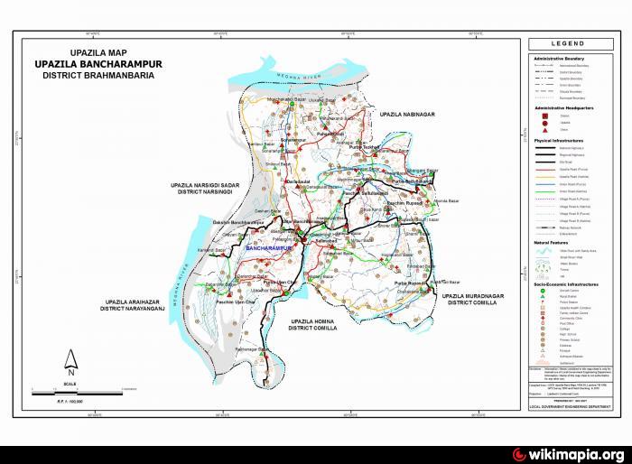
Bancharampur Upazila (Brahmanbaria district) with an area of 217.38 sq km, is bounded by Meghna river and Raipur upazila on the north, Homna upazila on the south, Nabinagar and Muradnagar upazilas on the east and Narshingdi sadar and Araihazar upazilas and Meghna river on the west. Main river is Meghna and Titas; Bamandhar, Chandal Beel is notable.
The location of the Bancharampur town is 23.7720772N 90.8014126E. Banchharampur (Town) consists of two mouzas. The area of the town is 10.86 sq km. It has a population of 11808; male 50.58%, female 49.42%; population density per sq km 1087. Literacy rate among the town people is 28.2%. The town has one dakbungalow.
Banchharampur thana was established in 1910 and was turned into an upazila in 1985. The upazila consists of 13 union parishads, 76 mouzas and 118 villages.
As of the 1991 Bangladesh census, Population 258371; male 50.93%, female 49.07%; Muslim 94.49%, Hindu 5.04% and others 0.47%; ethnic nationals: 30 families.
Religious institutions Mosque 330, temple 4, tomb 1, orphanage 3, most noted of which is tomb of Shah Rahat Ali (Saifullah Kandhi).
Literacy and educational institutions Average literacy 20.75%; male 26.90%, female 14.60%. Educational institutions: college 4, high school 13, junior high school 1, madrasa 8, government primary school 93, non-government primary school 50, vocational training institute 1, music institution 2, sewing training centre 2, typing training centre 1.
Main occupations Agriculture 33.01%, agricultural labourer 12.21%, wage labourer 2.05%, handloom 18.47%, commerce 11.18%, service 5.95%, fishing 3.02%, industry 1.17%, others 12.94%.
Land use Total cultivable land 12588.43 hectares; single crop 66.13%, double crop 27.05% and treble crop land 6.82%.
Land control Among the peasants 22% are landless, 22% marginal, 32% small, 20% intermediate and 4% rich.
Fisheries, dairies, poultries Poultry 3, fishery 25, dairy 1.
Communication facilities Roads: pucca road 16.5 km, mud road 205 km; water ways 70 km.
Manufactories Rice mill 150, ice factory 4 and pen manufacturing industry 1.
Cottage industries Banchharampur is famous for weaving having 10500 hand operated looms. Besides, other cottage industries include goldsmith 60, blacksmith 30, wood work 500 and tailoring 600.
NGO activities Operationally important NGOs are Manab Kalyan Sangstha (MKS) and RUPEA.
Health centres Upazila health complex 1, family welfare centre 13, palli health centre 2 and veterinary hospital 1.
Nearby cities:
Coordinates: 23°46'19"N 90°47'59"E
- Keraniganj Upazila 56 km
- Dhobaura Upazila 165 km
- Patiya Upazila (পটিয়া) 188 km
- Anwara Upazila (আনোয়ারা) 197 km
- Chandanaish Upazila 203 km
- Banshkhali Upazila (বাঁশখালী উপজেলা) 207 km
- Nam Mẫu commune 1516 km
- Don Phong commune 1533 km
- Vu Loan commune 1576 km
- Chi Vien Commune 1617 km
- Bancharampur Mollah Bari 0.4 km
- cotton industry 0.6 km
- rupasdi village 6.3 km
- lakc 7.3 km
- Gopaldi Bazar 9 km
- gandra bazaar 10 km
- Bakhar Nagar 12 km
- Raipura Upazila 21 km
- Narsingdi District 28 km
- Dhaka Division 62 km
Comments