Nasirnagar Upazila HQ
Bangladesh /
Brahman Bariya /
Sarail /
World
/ Bangladesh
/ Brahman Bariya
/ Sarail
World / Bangladesh / Chittagong / Comilla / Brahmanbaria
township, subdistrict, fourth-level administrative division, local government
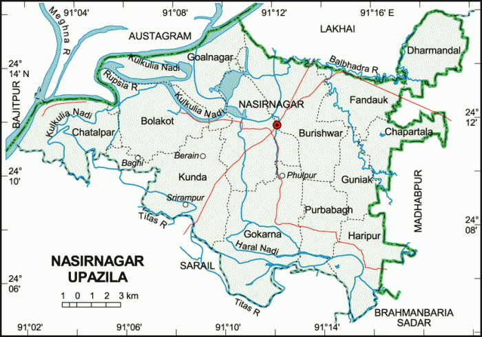
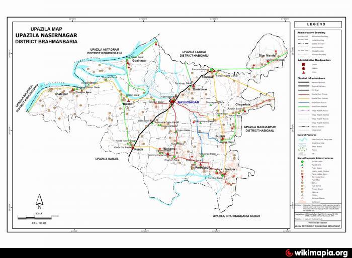
Nasirnagar Upazila (Brahmanbaria district) with an area of 311.66 sq km, is bounded by Lakhai and Austagram upazilas on the north, Sarail and Brahmanbaria sadar upazilas on the south, Madhabpur upazila on the east and Bajitpur and Austagram upazilas on the west. Main rivers are Meghna, Titas, Langan, Kulkuli, Balabhadra; noted depression: Shapla Beel, Medir Haor and Akashi Haor.
Nasirnagar is located at 24.2000°N 91.2097°E. It has 40917 units of house hold. Nasirnagar (Town) consists of two mouzas. The area of the town is 18.22 sq km. It has a population of 10731; male 50.97%, female 49.03%; population density per sq km 589. Literacy rate among the town people is 29.8%.
Nasirnagar thana, now an upazila, was established in 1910. The upazila consists of 13 union parishads, 100 mouzas and 129 villages.
As of 1991 Bangladesh census, Population 234090; male 50.45%, female 49.55%; Muslim 80.67%, Hindu 19.24% and others 0.09%.
Religious institutions Mosque 286, temple 37.
Average literacy 19.3%; male 25.6% and female 12.8%. Educational institutions: college 2, high school 15, junior high school 4, madrasa 16, government primary school 80, non-government primary school 35, satellite school 14, community school 4. Noted educational institutions: Phandauk PR High School (1938), Kuti Atal Bihari High School (1918).
Main occupations Agriculture 57.45%, agricultural labourer 16.91%, wage labourer 3.15%, commerce 8.03%, service 1.94%, fishing 2.89% and others 9.63%.
Land use Total cultivable land 27750 hectares; single crop 47.48%, double crop 42.31% and treble crop land 10.21%.
Communication facilities Roads: pucca 30 km, semi pucca 10 km.
Fisheries, poultries Poultry 25, hatchery 35.
Manufactories Rice mill, flour mill, oil mill, ice factory, saw mill, welding, etc.
Cottage industries Bamboo work 10, goldsmith 213, blacksmith 50, oil grinding (ghani) 170, brass work 21, potteries 117 and jute and cotton work 130.
Health centres Upazila health complex 1, family welfare centre 9 and satellite clinic 1.
NGO activities Operationally important NGOs are asa, brac, proshika, Save the Children, grameen bank, Langal Dhar, Anirban Sangsad, Comilla Proshika, Urban Bird, etc.
Nearby cities:
Coordinates: 24°11'41"N 91°11'52"E
- Rupganj Upazila 72 km
- Kapashia Upazila 73 km
- Gafargaon Upazila 85 km
- Matlab Upazila (North) Area 100 km
- Keraniganj Upazila 108 km
- Lohajang Upazila 123 km
- Dhobaura Upazila 141 km
- Patiya Upazila (পটিয়া) 214 km
- Chandanaish Upazila 226 km
- Banshkhali Upazila (বাঁশখালী উপজেলা) 234 km
- Madhir hawar (Edit By Md Babul Mia from Taka nagar ) 2.8 km
- KANDI GRAM Edit map by MONIR UL ISLAM 4.9 km
- Muslim Por Gram 6 km
- Gokarna Union 6.1 km
- Shahzadapur 12 km
- Molaish 13 km
- Dhauria 14 km
- Habigonj District 31 km
- Sylhet Division 70 km
- Dhaka Division 87 km
Comments