Jagannathpur Upazila
Bangladesh /
Sunamganj /
Chhatak /
Sunamganj
World
/ Bangladesh
/ Sunamganj
/ Chhatak
World / Bangladesh / Sylhet / Sylhet / Sun Amgonj
city, township, subdistrict, fourth-level administrative division, local government
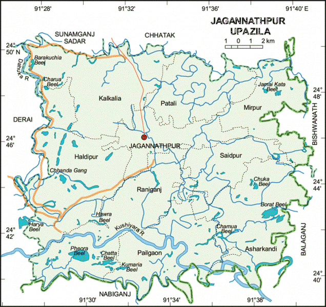

Jagannathpur (Devanagari: जगन्नथपुर, Bengali: জগন্নাথপুর) is an upazila located in the south-eastern corner of the district of Sunamganj and in the middle of the division of Sylhet, which is in north east of Bangladesh. The upazila is bordered with Chhatak in the north, to the east Bishwanath, to the south east is Balaganj, Nabiganj on the south, to the west Derai and Sunamganj Sadar in the north west.
Wikipedia article: https://en.wikipedia.org/wiki/Jagannathpur_Upazila
Nearby cities:
Coordinates: 24°46'28"N 91°33'7"E
- Gafargaon Upazila 114 km
- Kapashia Upazila 122 km
- Dhobaura Upazila 131 km
- Rupganj Upazila 137 km
- Matlab Upazila (North) Area 173 km
- Keraniganj Upazila 174 km
- Lohajang Upazila 192 km
- Patiya Upazila (পটিয়া) 271 km
- Chandanaish Upazila 280 km
- Banshkhali Upazila (বাঁশখালী উপজেলা) 290 km
- Nollah Haor 5.5 km
- Chauldane Haour 14 km
- Rohmot Pur & Chatol Par 17 km
- Biswanath, upazila Sylhet. 21 km
- Sunamganj District 28 km
- Sylhet Division 28 km
- Kaua Dighir Haowr 31 km
- Habigonj District 46 km
- Maulvibazar District 52 km
- Sylhet District 53 km
Comments