Ballyrobert Local Landscape Policy Area-Lisnalinchy Burn (Ballyrobert / Baile Róibirt)
United Kingdom /
Northern Ireland /
Ballyclare /
Ballyrobert / Baile Róibirt
World
/ United Kingdom
/ Northern Ireland
/ Ballyclare
World / United Kingdom / Northern Ireland
interesting place
Add category


This LLPA lies within and adjoins the Settlement Development Limit of Ballyrobert with parts of the LLPA falling within the Newtownabbey Countryside. It is considered to be of the greatest amenity value, landscape quality or local significance and must therefore be protected from undesirable or damaging development.
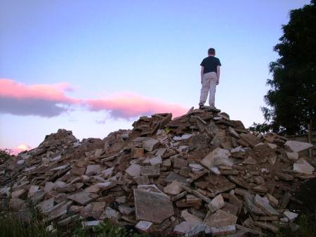
Due to Northern Ireland Planning Service and Northern Ireland Environmental Agency the LLPA has turned into a dump. These agencies and Newtownabbey Council are charged with protecting this LLPA. The photos will show how well they are doing their jobs.
Due to Northern Ireland Planning Service and Northern Ireland Environmental Agency the LLPA has turned into a dump. These agencies and Newtownabbey Council are charged with protecting this LLPA. The photos will show how well they are doing their jobs.
Nearby cities:
Coordinates: 54°43'12"N 6°0'17"W
- Dromore (An Droim Mór) 35 km
- Former RAF Mullaghmore 52 km
- Mulroy Bay (An Mhaoil Rua) 121 km
- Inishowen Peninsula (Inis Eoghain) 123 km
- Boa Island 124 km
- Barnesmore Gap 126 km
- HMS Audacious (Wreck) 130 km
- Rosguill Peninsula (Ros Goill) 133 km
- Sheep Haven Bay (Cuan na gCaorach) 138 km
- Leitrim Coast 156 km
- Former RAF Nutts Corner 14 km
- Black Mountain 14 km
- Ballydownfine 15 km
- Belfast International Airport 15 km
- Ulster Grand Prix - Dundrod circuit 15 km
- Andersonstown (Baile Andarsan) 16 km
- County Antrim 22 km
- Lough Neagh 29 km
- Glens of Antrim 31 km
- County Down 42 km