Khupa- takes in Hayuliyang's overflow
India /
Arunachal Pradesh /
Tezu /
World
/ India
/ Arunachal Pradesh
/ Tezu
World / India / Arunachal Pradesh / Lohit


On the site of an old village and above the gorge of the short Amliang river, before it meets the Lohit, is the well spaced largely Government town of Khupa. It has an excellent Government Rest House and a Tourist Home. Unlike Hayuliyang it has lots of open grounds and less visible filth. It has one lovely walk and gorgeous views! About two kms up the road is Tafliang village, where opium is grown and sold.
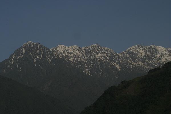
That snow ridge has peaks of 3375, 4254 and 4301. They could perhaps be called Tidding Peaks. To the left of them (not seen) are another set of peaks that could be called Tinning Peaks.
That snow ridge has peaks of 3375, 4254 and 4301. They could perhaps be called Tidding Peaks. To the left of them (not seen) are another set of peaks that could be called Tinning Peaks.
Nearby cities:
Coordinates: 28°4'1"N 96°29'26"E
- Opium growing village of Tafliang 1.7 km
- Opium fields of Raliang and Gaen 11 km
- khada 44 km
- Tri-Junction. 45 km
- Yellow Pimple 47 km
- Kalai-I HEP 48 km
- Ashi Hill 50 km
- Lachman Ridge 50 km
- West Ridge 51 km
- Maha Plateau 52 km
- Dulai River Estuary 3.9 km
- Telu Nala 8.3 km
- Tidding - Lohit confluence 14 km
- Kasomathag 4697 m 32 km
- Pond 35 km
- Kamlang Wildlife Sanctuary 36 km
- Tho Chu Tuwi 39 km
- Glo Hawel Lake 41 km
- Lake 42 km
- Kraoti Tuwi 43 km