Mariveles Harbour
Philippines /
Central Luzon /
Alas-asin /
World
/ Philippines
/ Central Luzon
/ Alas-asin
World / Philippines / Bataan / Mariveles
historic landmark
Add category
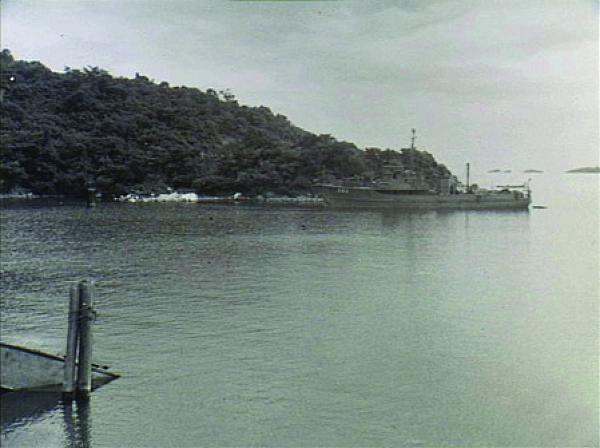
Mariveles, Luzon, Philippines, 1945-06. The US Navy Yard Minesweeper YMS 393 at anchor in Mariveles Harbour. Lieutenant John Betty RANVR was attached to YMS 393 for six weeks in 1945 to undertake hydrographic surveys, sweeping anchorages, fixing navigational beacons and charting and buoying wrecks of ports and harbours in the northern Philippines. (Donor J.Betty)
Nearby cities:
Coordinates: 14°25'36"N 120°31'47"E
- Hue Outer city wall 1410 km
- Tien Duc Commune, 1675 km
- Special National Vestige Con Son 1681 km
- Hoa Lu Ancient Capital. 1687 km
- Peleliu (Beliliou) Island 1706 km
- West Lake 1726 km
- Phou Keng 1942 km
- Namhansanseong 2650 km
- Taehung Fortress 2700 km
- Hwangryong Fortress 2763 km
- Mariveles Coal-Fired Power Plant 0.8 km
- GN Dinginin Power Station 1.4 km
- The Mariveles Cove 2.8 km
- Cochinos (Pitas) 3.9 km
- Mariveles Town Proper 4.9 km
- Longos Kawayan Point 6.7 km
- Corregidor Island (Fort Mills) 8.2 km
- Corregidor Caldera 10 km
- Bataan 30 km
- Manila Bay 31 km