Bloemhof dam
South Africa /
Free State /
Hoopstad /
World
/ South Africa
/ Free State
/ Hoopstad
World / South Africa / Orange Free State
lake
Add category
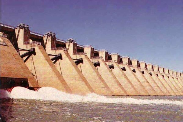
Bloemhof Dam is situated on the Vaal River, downstream of Vaal Dam approximately 2km upstream of the town of Bloemhof. The dam, originally known as Oppermansdrif Dam was constructed during the late sixties and was commissioned in 1970. It is a composite dam comprising earthfill flanks on each side of a 305m long central concrete spillway. Due to the flat topography of the area, the dam wall is very long with a total crest length of 4 270m and a maximum wall height of only 35.2m above deepest foundation level.
At full supply the capacity of Bloemhof Dam is 1 269 million m3 with a surface area of 223km2. It is therefore a very large and shallow reservoir in an area with relatively low rainfall ( 474mm/a ) and high potential evaporation ( ~1800mm/a ).
Bloemhof Dam was constructed to impound runoff originating below the Vaal Dam to meet the needs of users in the Lower Vaal River area. The dam supplies water to various industrial and municipal users although most of the water released from the dam is used for riparian irrigation along the Vaal River totaling 17 000ha. Water is also released from Bloemhof Dam to augment supplies to the Vaalharts Government Water Scheme where approximately 37 000ha are under irrigation. The Vaalharts scheme is currently the largest user of water from Bloemhof Dam and the water released from Bloemhof Dam is diverted from the Vaalharts Weir via canal to the irrigation scheme in the Vaalharts River catchment - a tributary of the Vaal River.
Nearby cities:
Coordinates: 27°39'54"S 25°48'37"E
- Vaal Dam (man-made lake) 244 km
- Katse Dam 298 km
- Sterkfontein Dam 321 km
- Woodstock Dam 344 km
- Rhenosterkop Reservoir 414 km
- Hayshope Reservoir 458 km
- Pongolapoort Dam 601 km
- Lake Sibhayi 668 km
- Massingir Dam 748 km
- Lake Ihotry 1907 km
- Target Gold Mine 81 km
- Target 3 Gold Mine 85 km
- Jeanette Gold Project 88 km
- Freddies Consolidated Mines Limited 91 km
- Hilton Gold Project 92 km
- Phakisa Gold Mine 96 km
- Welkom Gold Mine 96 km
- St. Helena Gold Mine 99 km
- Weltevreden Gold Mine 107 km
- Beatrix Gold Mine 111 km