Size of the Black Sea about 5.600 B.C
Ukraine /
Krym /
Kurpaty /
World
/ Ukraine
/ Krym
/ Kurpaty
, 166 km from center (Курпати)
World / Turkey / Kastamonu
historical layer / disappeared object
Add category

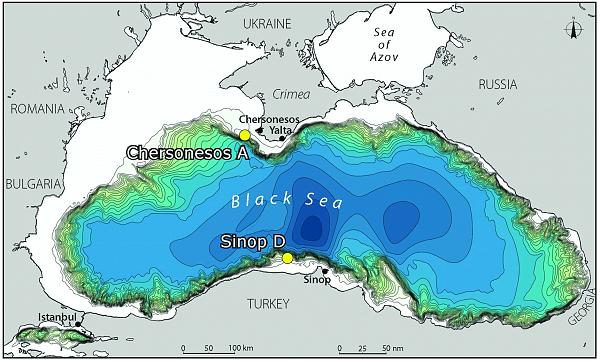
In 1998, William Ryan and Walter Pitman, geologists from Columbia University, published evidence that a massive flood through the Bosporus occurred about 5600 BC. Glacial meltwater had turned the Black and Caspian Seas into vast freshwater lakes, while sea levels remained lower worldwide. The fresh water lakes were emptying their waters into the Aegean Sea. As the glaciers retreated, rivers emptying into the Black Sea reduced their volume and found new outlets in the North Sea, and the water levels lowered through evaporation. Then, about 5600 BC, as sea levels rose, Ryan and Pitman suggest, the rising Mediterranean finally spilled over a rocky sill at the Bosporus. The event flooded 155,000 km2 (60,000 sq mi) of land and significantly expanded the Black Sea shoreline to the north and west.
Second Graphic: Institute for Archaeological Oceanography,
University of Rhode Island
Second Graphic: Institute for Archaeological Oceanography,
University of Rhode Island
Wikipedia article: http://en.wikipedia.org/wiki/Black_Sea_deluge_theory
Nearby cities:
Coordinates: 42°58'46"N 35°0'28"E
- 19 Mayıs Stadium 220 km
- Lighthouse 98 km
- The most northern point of Turkey 98 km
- Gerne Mevki Ada 99 km
- Akliman 103 km
- Sinop (Province) 149 km
Comments