Ravna Gora
Serbia and Montenegro /
Central Serbia /
Ljig /
World
/ Serbia and Montenegro
/ Central Serbia
/ Ljig
, 15 km from center (Љиг)
World / Serbia / Kolubarski
mountain, park, interesting place


Ravna Gora is a raised plateau on the environment. The overall slope of Valjevo mountain plateau to the north (down basin), and then to the bottom Nakucanske presedline (between mountains) shows that building the southern part of the relief Kolubara done confrontation of two opposing processes: erozionog, which tends to uravni that part of the dinar and the courts tektonskog, which were built izdizani some parts of the surface. According to the East Flat worse binds to Suvobora branches. Highest level in this area build curved scalp several peaks on the southern edge of the river basin Paleznicke, which approximate height: Lom (716 m), Igriste (730 m), Damjanov stone (725 m), Vezinac (760 m), and Suvobor (864 m), Tang (845 m), Grukovica (855 m) and Paradise Mountain (848 m). They are slightly rise above the plateau and presedlina of about 800 m, and are very denivelisane surface residues of 850-920 m. Plateau at about 800 m is better expressed north of Suvobora. to continue in the spacious plateau right-field block (at 780-800 m), which was cut in suvoborske serpentinite. The plateau is pulling presedlinom between Grukovice and Rajac. At the same height as the east of the scalp Rajac hill until the Fat Brdo, which is clearly rising to the surface of 700 m. This surface reaches a width of 5 km. The largest part of the Straight Up affect gornjekredni limestones presented a reddish-purple and silifikovanim panel, compact, laporovitim limestones. They are expressed on the northwestern side. Limestone terrain is straight up depressions, depressions, and caves, among which emphasize wet and dry cave. Karst straight up has an area of 3 km2. To the west of the Ravna Gora and Bačevačko Lelicka, and the east Rajac surface, where they identified identical structures of the upper chalk.
WHAT TO SEE IN Ravna Gora?
* Drazin cave
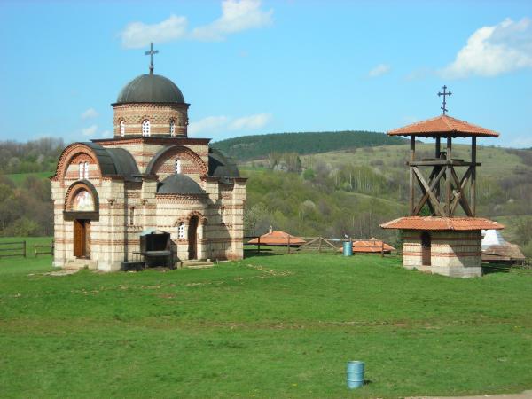
* Church of Saint George
* Top of Babin Kuk
WHAT TO SEE IN Ravna Gora?
* Drazin cave
* Church of Saint George
* Top of Babin Kuk
Nearby cities:
Coordinates: 44°6'52"N 20°8'56"E
- Zlatibor 60 km
- Gledić mountains 60 km
- Golija 66 km
- Juhor mountain 85 km
- Jastrebac Mountain 108 km
- Homolje mountains 114 km
- Locvei Mountains 132 km
- Rtanj Mountain 135 km
- Svrljig Mountains 170 km
- Suva Planina 171 km
- Osecenica 11 km
- Vrujci 12 km
- Lubenin 15 km
- Ljig Municipality 16 km
- Ivanovica 16 km
- Poljanice 19 km
- Djurdjevac 19 km
- selo nanomir 22 km
- military VS 23 km
- Slovac Quarry 25 km