Drawbridge, California (Fremont, California)
USA /
California /
Fremont /
Fremont, California
World
/ USA
/ California
/ Fremont
World / United States / California
ghost town
Add category

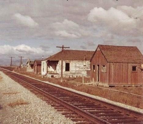

Hidden on the edge of the salt flats, Drawbridge was founded in the late 1870s when a narrow gauge railroad was built from Dumbarton Point to Santa Clara with two swing bridges connecting tiny Station Island to shore. A colorful community developed in this most unlikely environment along the railroad tracks. Now a ghost town, Drawbridge was featured on Huell Howser's "California Gold" on PBS-TV.
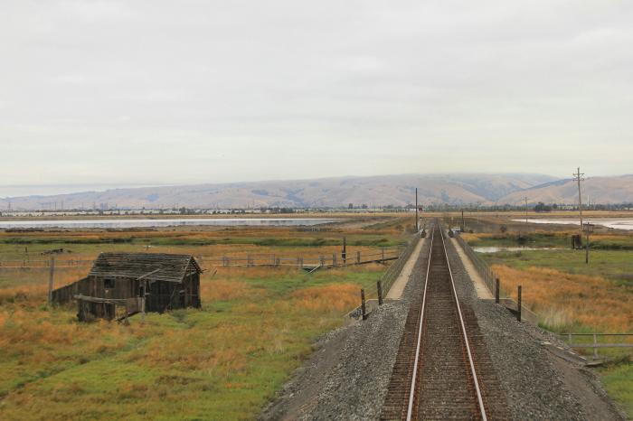
Once a pristine area with prime duck hunting and fishing opportunities (early photos attest to this with people loaded down with duck carcasses and boats full of fish) that attracted the independent sort, it was not to last. By the 1930s, untreated sewage was pumped into Coyote Creek by Fremont, Hayward, and San Jose. This decimated the ecosystem and turned a natural paradise into a stinking ruin. The smell alone caused many residents to flee. Salt ponds were carved out of the island, further destroying wetland habitat relied upon by waterfowl and other animals. The pure artesian well water this place was known for was destroyed through overpumping by local communities lowering the water table, which caused the waterline to recede and the wells turning saline. Thus, local residents had to extend their walkways to the water, or change their orientation altogether. The walkway leading to Charlie Luce's house, for example, was originally located on the north side of the house and was later moved to the south.
Drawbridge now sits slowly sinking into the Bay as nature begins to slowly reclaim the once active town now being used as strictly as a wildlife area. Though technically illegal to go into, many make the venture to Drawbridge via the only way in, the Amtrak and Altamont Express train line, though dangerous, many time it with when the train leaves Great America Station and arrives in Fremont or vice versa as it is a single train line.
www.youtube.com/watch?v=A_cT6s__btU
www.fws.gov/uploadedFiles/Region_8/NWRS/Zone_2/San_Fran...
sfbws.com/drawbridge#visual-history-drawbridge
shannonebarry.blogspot.com/2012/08/visiting-south-bay-g...
www.sanjose.com/underbelly/unbelly/Draw/draw1.html
sfbws.com/sites/default/files/drawbridge/Drawbridge-sli...
www.flickr.com/photos/kapshure/albums/72157603902015751...
Wikipedia article: http://en.wikipedia.org/wiki/Drawbridge,_California
Nearby cities:
Coordinates: 37°27'55"N 121°58'27"W
- Alum Rock Park 15 km
- Tammukan, California 58 km
- China Camp State Park 77 km
- Bodie State Historic Park 273 km
- Palisades del Rey (Surfridge Ghost Town) 504 km
- McGill, Nevada 663 km
- Barclay, Nevada 679 km
- Kaiser Mine and Ghost Town 701 km
- Bombay Beach, California 726 km
- Wolf Hole, Arizona 749 km
- Salt Pond A14 2.1 km
- West Industrial 2.6 km
- East Industrial 3.7 km
- Alviso 3.8 km
- San Jose / Santa Clara Water Pollution Control Plant 4.2 km
- Pond 4.2 km
- Don Edwards San Francisco Bay National Wildlife Refuge 9 km
- Border 1 10 km
- Alameda County, California 24 km
- Santa Clara County, California 32 km
Comments