Munshiganj Dist Town
Bangladesh /
Narayanganj /
World
/ Bangladesh
/ Narayanganj
/ Narayanganj
World / Bangladesh / Dhaka / Dhaka / Munshigonj
third-level administrative division, local government, town district
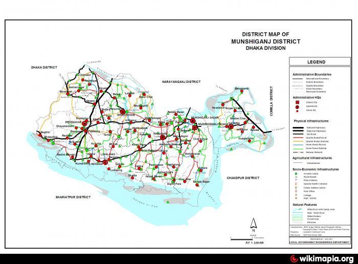
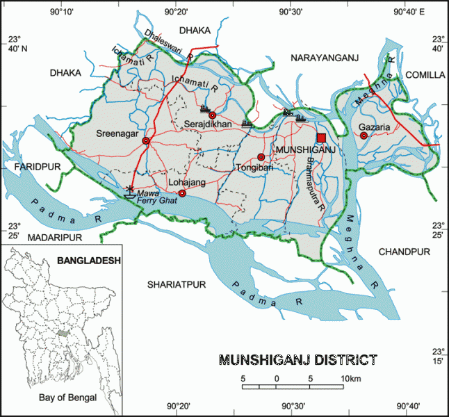
Munshiganj District (Dhaka division) with an area of 954.96 sq km, is bounded by Dhaka and Narayanganj districts on the north, Madaripur and Shariatpur districts on the south, Comilla and Chandpur districts on the east, Dhaka and Faridpur districts on the west. Main rivers are the Padma, Meghna, Dhaleshwari, Ichamati and Shitalakshya. The southern and eastern parts of the district often fall victim to erosion caused by the mighty Padma and the Meghna respectively. Main depression is Arial Beel covering an area of 4330 hectare. Annual temperature- maximum 36°C and minimum 12.7°C; total rainfall 2376 mm.
Munshiganj district, formerly a subdivision under Dhaka district, was established in 1984. It consists of 6 upazilas, 67 union parishads, 662 mouzas, 906 villages, 18 wards, 73 mahallas and 2 municipalities. The upazilas are gazaria, tongibari, serajdikhan, lohajang, sreenagar and munshiganj sadar.
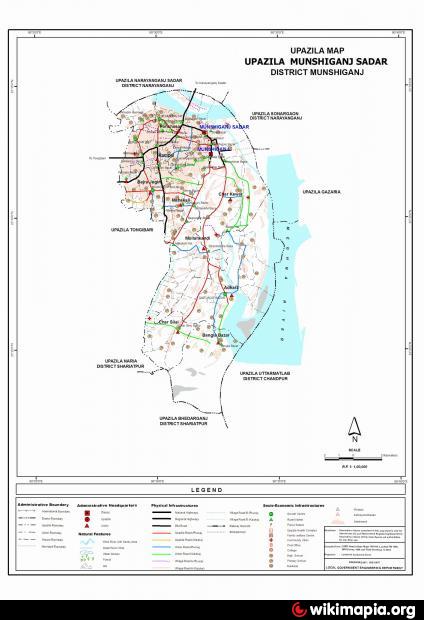
Munshiganj Sadar is an Upazila of Munshiganj District in the Division of Dhaka, Bangladesh. Munshiganj Sadar has 12 Unions/Wards, 129 Mauzas/Mahallas, and 219 villages.
Munshiganj town is located at 23.4583°N 90.5417°E. It has 50609 units of house hold and total area 160.79 km². Munshiganj (Town) consists of 9 wards and 42 mahallas.The area of the town is 14.17 km2. The population of the town is 52071; male 51.62% and female 48.38%; density of population is 3674 per km2. Literacy rate among the town people is 49.3%.
Historical events: The area comprising the districts of Munshiganj stretching on the west of the Meghna and Dhaleshwari including the area known as Bikramapur. During the Sena rule Bikramapur in East Bengal had been stated to be the second capital of the Senas in addition to their capital at Nadia. After the fall of Nadia in the hands of Bakhtiyar khalji (1204) and his troops, the Sena King Lakshmanasen fled to Bikramapur and took refuge there. After his death, Raja Danujmardhan ousted the Senas from Bikramapur in the third quarter of the thirteenth century.
During the Mughal period, the present Munshiganj town including the outlying areas was known as Idrakpur which was named after the then Mughal Faujdar Idrak. A village on the outskirts of Munshiganj town is still known as Idrakpur. During the British rule Idrakpur was renamed as Munshiganj after the name of Munshi Enayet Ali, the local zamindar and the inhabitant of the village Kazi Kasba in Rampal.
Archeological heritage: Idrakpur Fort (1660) at Munshigonj town, Panditer Bhita (birth place of Atis Dipankar at Vajrayogini, Baba Adam’s Mosque at Rampal, homestead of Raja Vallala Sena, Rampal Dighi, Raja Harish Chandra’s Dighi, Kodal Dhoar Dighi, Talukdarbari Mosque at Kusumpur, Tajpur Mosque, Patharghata Mosque, Kazishal Mosque, Palghata Bridge, Panch Pir Dargah.
As of the 1991 Bangladesh census, Population 1293536; male 50.09%, female 49.91%; Muslim 90.78%, Hindu 8.01%, Christian 1.2%, Buddhist 0.01%. Ethnic nationals include snake charmers, cobblers (Rishi) and scavengers of Munshir Hat.
Religious institutions Mosque 1478, temple 108, tomb 10, church 9.
Literacy and educational institutions Average literacy 35.8%; male 40.3%, female 31.1%. Educational institutions: college 16, high school 82, junior high school 11, primary training institute 1, technical training centre 3, madrasa 87, government primary school 423, non-government primary school 78, kindergarten 5, mass-education centre 688.
Cultural organisations Club 267, public library 16, various organisations 378, women's association 47, theatre group 10, jatra party 2, drama stage 1, cinema hall 15, stadium 2, museum 1, musical academy 2, art school 1.
Main occupations Agriculture 27.43%, agricultural labourer 21.96%, fishing 2.25%, hawker 1.02%, construction 1.57%, commerce 19.46%, service 9.28%, transport 1.67%, wage labourer 2.87% and others 12.49%.
Land use Cultivable land 56594 hectares; single crop 23%, double crop 44%, triple crop land 33%. Arable land under irrigation 36%.
Land control Among the peasants, 13.2% are landless, 27.06% marginal, 35.26% small, 18.65% intermediate, 5.83% rich; cultivable land per head 0.047 hectare.
Main crops: Potato, jute, rice, betel leaf, wheat, mustard, sesame, gram, lentil, pea, chilli, coriander, ground nut, maize, patal, karalla tomato, sweet pumpkin, vegetables. Munshiganj is one of the largest producer of potato in Bangladesh.
Fisheries, poultries and dairies Livestock and dairy 309, poultry 237, fishery 179, hatchery 6.
Communication facilities Roads: pucca 242.27 km, semi pucca 127 km, mud road 1339 km; launch ghat 29, ferry ghat 16, boat mahal 5.
Manufactories Large industries 6, medium industries 20, ice mill and cold storage 60, rice mill 19, saw mill 27.
Cottage industries Cottage industries of various categories 727.
NGO activities Operationally important NGOs are asa, brac, grameen bank, caritas, World Vision, proshika, Samaj Parivartan Kendra, Country Mission, CARE, RSD, Vikrampur Ayn Sahajya Sangstha, Yuba Sangha, Mahila Angana.
Health centres: Hospital 1, upazila health complex 5, family planning centre 48, satellite clinic 22, mother and child care centre 1, charitable dispensary 4, private clinic 4, pathological laboratory 3, artificial breeding centre 1, veterinary hospital 7.
Munshiganj district, formerly a subdivision under Dhaka district, was established in 1984. It consists of 6 upazilas, 67 union parishads, 662 mouzas, 906 villages, 18 wards, 73 mahallas and 2 municipalities. The upazilas are gazaria, tongibari, serajdikhan, lohajang, sreenagar and munshiganj sadar.
Munshiganj Sadar is an Upazila of Munshiganj District in the Division of Dhaka, Bangladesh. Munshiganj Sadar has 12 Unions/Wards, 129 Mauzas/Mahallas, and 219 villages.
Munshiganj town is located at 23.4583°N 90.5417°E. It has 50609 units of house hold and total area 160.79 km². Munshiganj (Town) consists of 9 wards and 42 mahallas.The area of the town is 14.17 km2. The population of the town is 52071; male 51.62% and female 48.38%; density of population is 3674 per km2. Literacy rate among the town people is 49.3%.
Historical events: The area comprising the districts of Munshiganj stretching on the west of the Meghna and Dhaleshwari including the area known as Bikramapur. During the Sena rule Bikramapur in East Bengal had been stated to be the second capital of the Senas in addition to their capital at Nadia. After the fall of Nadia in the hands of Bakhtiyar khalji (1204) and his troops, the Sena King Lakshmanasen fled to Bikramapur and took refuge there. After his death, Raja Danujmardhan ousted the Senas from Bikramapur in the third quarter of the thirteenth century.
During the Mughal period, the present Munshiganj town including the outlying areas was known as Idrakpur which was named after the then Mughal Faujdar Idrak. A village on the outskirts of Munshiganj town is still known as Idrakpur. During the British rule Idrakpur was renamed as Munshiganj after the name of Munshi Enayet Ali, the local zamindar and the inhabitant of the village Kazi Kasba in Rampal.
Archeological heritage: Idrakpur Fort (1660) at Munshigonj town, Panditer Bhita (birth place of Atis Dipankar at Vajrayogini, Baba Adam’s Mosque at Rampal, homestead of Raja Vallala Sena, Rampal Dighi, Raja Harish Chandra’s Dighi, Kodal Dhoar Dighi, Talukdarbari Mosque at Kusumpur, Tajpur Mosque, Patharghata Mosque, Kazishal Mosque, Palghata Bridge, Panch Pir Dargah.
As of the 1991 Bangladesh census, Population 1293536; male 50.09%, female 49.91%; Muslim 90.78%, Hindu 8.01%, Christian 1.2%, Buddhist 0.01%. Ethnic nationals include snake charmers, cobblers (Rishi) and scavengers of Munshir Hat.
Religious institutions Mosque 1478, temple 108, tomb 10, church 9.
Literacy and educational institutions Average literacy 35.8%; male 40.3%, female 31.1%. Educational institutions: college 16, high school 82, junior high school 11, primary training institute 1, technical training centre 3, madrasa 87, government primary school 423, non-government primary school 78, kindergarten 5, mass-education centre 688.
Cultural organisations Club 267, public library 16, various organisations 378, women's association 47, theatre group 10, jatra party 2, drama stage 1, cinema hall 15, stadium 2, museum 1, musical academy 2, art school 1.
Main occupations Agriculture 27.43%, agricultural labourer 21.96%, fishing 2.25%, hawker 1.02%, construction 1.57%, commerce 19.46%, service 9.28%, transport 1.67%, wage labourer 2.87% and others 12.49%.
Land use Cultivable land 56594 hectares; single crop 23%, double crop 44%, triple crop land 33%. Arable land under irrigation 36%.
Land control Among the peasants, 13.2% are landless, 27.06% marginal, 35.26% small, 18.65% intermediate, 5.83% rich; cultivable land per head 0.047 hectare.
Main crops: Potato, jute, rice, betel leaf, wheat, mustard, sesame, gram, lentil, pea, chilli, coriander, ground nut, maize, patal, karalla tomato, sweet pumpkin, vegetables. Munshiganj is one of the largest producer of potato in Bangladesh.
Fisheries, poultries and dairies Livestock and dairy 309, poultry 237, fishery 179, hatchery 6.
Communication facilities Roads: pucca 242.27 km, semi pucca 127 km, mud road 1339 km; launch ghat 29, ferry ghat 16, boat mahal 5.
Manufactories Large industries 6, medium industries 20, ice mill and cold storage 60, rice mill 19, saw mill 27.
Cottage industries Cottage industries of various categories 727.
NGO activities Operationally important NGOs are asa, brac, grameen bank, caritas, World Vision, proshika, Samaj Parivartan Kendra, Country Mission, CARE, RSD, Vikrampur Ayn Sahajya Sangstha, Yuba Sangha, Mahila Angana.
Health centres: Hospital 1, upazila health complex 5, family planning centre 48, satellite clinic 22, mother and child care centre 1, charitable dispensary 4, private clinic 4, pathological laboratory 3, artificial breeding centre 1, veterinary hospital 7.
Nearby cities:
Coordinates: 23°33'0"N 90°31'7"E
- Narsingdi District 78 km
- Feni 78 km
- Bhola District Town 92 km
- Khagrachari District 124 km
- Habigonj District 152 km
- Rangamati District 154 km
- Maulvibazar District 177 km
- Sunamganj District 190 km
- Sylhet District 214 km
- Jiuzhaigou County 1695 km
- Tongibari Upazila HQ 6.9 km
- MAKAHATI VILLAGE 7.6 km
- Rongmehar,Tongibari,munshigonj 8.1 km
- MALKHANAGOR 9 km
- Sirajdikhan Upazila HQ 14 km
- Old Bangla Bazaar 16 km
- Lohajang Upazila 19 km
- Bora Char.Motlab.Chandpur 23 km
- Dhaka Division 68 km
- TROPIC OF CANCER 984 km
Comments