Mellon Charles (Loch Ewe) Depot
United Kingdom /
Scotland /
Ullapool /
World
/ United Kingdom
/ Scotland
/ Ullapool
World
naval base
Add category
Mellon Charles (Loch Ewe) Depot
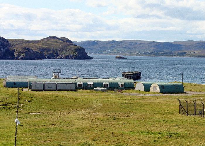
This Royal Navy depot and military camp is situated on the shore at Gainmheach Mhor. The depot consists of a pier, slipway and many buildings, many of which are still in use.The main group of buildings are at NG 84547 91126, the slipway at NG 84427 91041 and the pier at NG 84435 90931.
The depot is visible on RAF vertical air photographs (CPE/Scot/UK182, 1348-1350, flown 8 October 1946) which shows that during WW II it was linked closely to the maintenance of the anti-submarine boom. Visible on the photographs is much of the paraphernalia connected with boom defence work. Submarine nets were placed across the mouth of Loch Ewe at this point to protect the gathering Russian Convoys that used the Loch as a safe haven. Since the war, most of the Nissen huts have been replaced by modern huts and several larger sheds.The depot is annotated on the current OS digital 1;2500 scale map as being disused.
The site was apparently still in use until recently. The fenced area is an automated weather station operation by the MET Office. Informed speculation has the former boom camp playing a role in the disposal at sea of low to intermediate grade nuclear wastes from the UK Nuclear Submarine fleet
canmore.rcahms.gov.uk/en/site/79434/details/mellon+char...
www.drookitagain.co.uk/coppermine/displayimage.php?pid=...
Nearby cities:
Coordinates: 57°51'27"N 5°38'0"W
- Naval Station Rota 2360 km
- Naval Air Station Patuxent River (NHK/KNHK) 5404 km
- Norfolk, Virginia 5508 km
- Naval Station Norfolk (NGU/KNGU) 5509 km
- Naval Air Station Whiting Field (NSE/KNSE) and (NDZ/KNDZ) 6671 km
- Naval Air Station Whidbey Island (NASWI) Ault Field 6883 km
- Guantanamo Bay Naval Base 6944 km
- Naval Air Station Lemoore 7903 km
- Naval Air Station Point Mugu 8079 km
- Pearl Harbor 10850 km
- The Minch 30 km
- Rona 40 km
- Meall na Suiramach (The Quiraing) 44 km
- Shiant Isles 44 km
- Raasay 54 km
- Isle of Skye 67 km
- Isle of Lewis 71 km
- Loch Dunvegan 74 km
- Harris 75 km
- Taransay 83 km