Nawabganj Upazila HQ
Bangladesh /
Dinajpur /
Fulbari /
World
/ Bangladesh
/ Dinajpur
/ Fulbari
World / Bangladesh / Rajshahi / Dinajpur / Dinajpur
township, subdistrict, fourth-level administrative division, local government
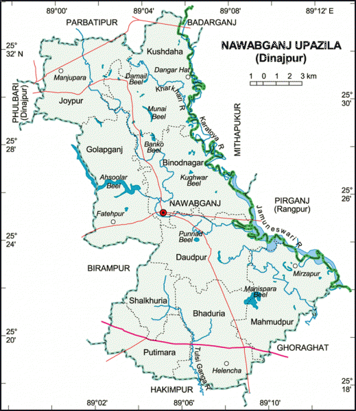

Nawabganj Upazila (Dinajpur district) with an area of 314.68 sq km, is bounded by Phulbari upazila (Dinajpur) on the north, Ghoraghat and Hakimpur upazilas on the south, Pirganj, Mithapukur and Badarganj upazilas on the east, Birampur and Phulbari upazilas on the west. Karatoya, Jamuneshwari and Tulsiganga rivers and Asurar Beel are notable.
Nawabganj town is located at 25.4185645N 89.0754747E. Nawabganj (Town) consists of 4 mouzas with an area of 3.48 sq km. The town has a population of 4196; male 54.96%, female 45.04%. The density of population is 1206 per sq km. The literacy rate among the town people is 45.4%.
Nawabganj thana was established in 1899 and was turned into an upazila in 1983. It consists of 9 union parishads, 212 mouzas, 271 villages.
As of 1991 Bangladesh census, Population 170301; male 51.77% and female 48.23%; Muslim 86.48%, Hindu 8.05%, Christian 1.22% and others 4.25%.
Religious institutions Mosque 310, temple 7, church 5.
Literacy and educational institutions Average literacy 24.2%; male 31.4%, female 16.5%.
Educational institutions: college 9, private high school 19, primary school 67, madrasa 51.
Main occupations Agriculture 49.65%, agricultural labourer 28.91%, wage labourer 2.54%, commerce 8.49%, service 2.63%, others 7.78%.
Land use Cultivable land 23322.54 hectares, fallow land 667.75 hectares; single crop 34%, double crop 51% and treble crop land 15%.
Land control Among the peasants, 26% are landless, 34% small, 35% medium, 5% rich; per capita cultivable land 0.17 hectare.
Poultries 3.
Communication facilities Roads: pucca 39 km, semi pucca 5 km and mud road 560 km.
Manufactories: Rice-husking mill 45, automatic rice mill 1, ice factory 3, biscuit factory 3 and saw mill15.
Cottage industries: Potteries, blacksmith, goldsmith, tailoring, welding etc.
NGO activities Operationally important NGOs are grameen bank, brac, asa, ccdb, caritas, UDP, tmss and Pallibandhu Parishad.
Health centres Upazila health complex 1 and union health and family planning centre 9.
Nearby cities:
Coordinates: 25°25'6"N 89°4'53"E
- Gobindaganj Upazila 24 km
- Shaghatta Upazila 45 km
- Sarishabari Upazila 92 km
- Bholahat Upazila HQ 103 km
- Abhaynagar Upazila HQ 264 km
- Fakirhat Upazila HQ 297 km
- Kachua Upazila HQ 315 km
- Koyra Upzila HQ 338 km
- Maidi Vdc 514 km
- Samote Union Council 1754 km
- নবাবগঞ্জ জাতীয় উদ্যান 2.8 km
- আশুড়ার বিলঃ মইলা নদীর শুরু/মরা করতোয়া 3.5 km
- ্মইলা নদী/ মরা করতোয়া-২ নং ধারা 14 km
- HILI, DINAJPUR 23 km
- মইলা নদী বা মরা করতোয়া-২ নং ধারা 25 km
- Rajshahi Division 26 km
- Rangpur District 27 km
- Ghoraghat Durga/Fort, Ghoraghat 30 km
- Dinajpur District 37 km
- Gaibandha District 40 km