Joypurhat
Bangladesh /
Jaipur Hat /
World
/ Bangladesh
/ Jaipur Hat
/ Jaipur Hat
World / Bangladesh / Rajshahi / Bogra / Jaipurhat
town
Add category


Joypurhat District (Rajshahi division) with an area of 965.44 sq km, is bounded by Dinajpur district on the north, Naogaon districts on the south, Bogra and Gaibandha districts on the east, Bogra and Naogaon districts and Indian province of West bengal on the west. Main rivers are little jamuna, Tulsi Ganga and Haramati. Annual average temperature: maximum 34.6°C, minimum 11.9°C; annual rainfall is 1610 mm.
The location of Joypurhat district town is 25.1004975N 89.0335387E. Joypurhat (Town) consists of 9 wards and 48 mahallas. The area of the town is 18.53 km. The town has a population of 56323; male 51.60%, female 48.40%. Literacy rate among the town people is 51.4%. It has a circuit house and a dakbungalow.Joypurhat (Town) consists of 9 wards and 48 mahallas. The area of the town is 18.53 km. The town has a population of 56323; male 51.60%, female 48.40%. Literacy rate among the town people is 51.4%. It has a circuit house and a dakbungalow.
Joypurhat was the only subdivision of the erstwhile Bogra district, and since 1984 it has been turned into a district. The district consists of 3 municipalities, 27 wards, 5 upazilas, 32 union parishads, 719 mouzas, 74 mahallas and 898 villages. The upazilas are joypurhat sadar, akkelpur, kalai, khetlal and panchbibi.
Archaeological heritage and relics: the Garuda Pillar at Bhimer Panti, Dargah of Nimai Pir.
As of the 1991 Bangladesh census, Population 844818; male 51.03%, female 48.97%; Muslim 88.18%, Hindu 9.57%, tribles and others 2.25%; ethnic nationals: Santal, Orao, Munda, Mahali, Koch, Pahan, Buna, Ho, Mahato, Rajbangshi and Koch are noted trible.
Religious institutions Mosque 1644, temple 104, church 9, mazar 6, sacred place 3.
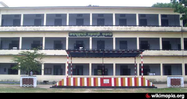
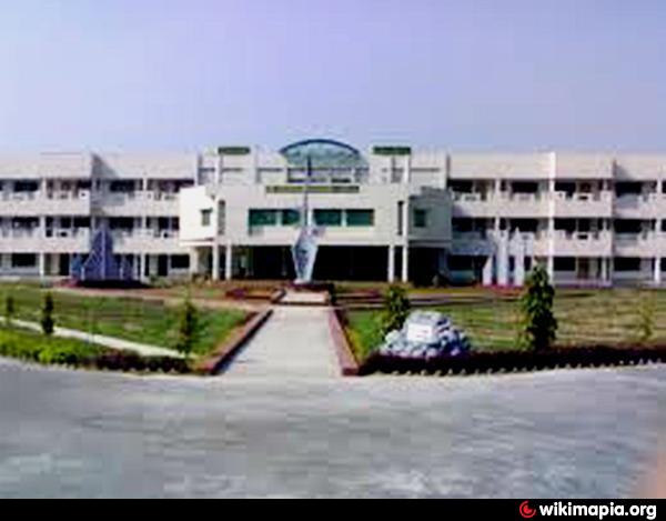
Literacy and educational institutions Average literacy 19.8%; male 27.4% and female 11.8%. Educational institutions: government college 2, non-government college 15, junior school 13, law college 1, primary education training institute 1, vocational training institute 1, technical college 1, government high school 2, non-government high school 76, government primary school 209, non-government primary school 56, madrasa 83. Noted educational institutions: Kalai Mayen Uddin High School (1913), Sonamukhi High School (1916), Khanjanpur High School (1917), Khanjanpur Mission Girl's High School (1919), Karai Nurul Huda Aliya Madrasa (1926), Baniapara Madrasa (1936), Teghar High Madrasa (1939), Ramdeo Bajla Government High School (1946), Joypurhat Government College (1946).
Cultural organisations Library 7, club 224, cinema hall 15, women's organisation 75, theatre group 5, literary society 8, theatre place 1, shilpakala academy 1, co operative society 36.
Main occupations Agriculture 53.33%, agricultural labourer 24.85%, wage labourer 1.66%, commerce 9.95%, service 4.39%, transport 1.38%, others 7.44%.
Land use Cultivable land 80028 hectares, fallow land 20 hectares; single crop 5%, double crop 60% and treble crop land 35%; cultivable land under irrigation 85%.
Land control Among the peasants 11% are landless, 53.5% small, 21.8% intermediate and 13.7 rich; cultivable land per head 0.09 hectares.
Main crops: Paddy, potato, sugarcane, banana, jute, turmeric, mustard seed and vegetables.
Fisheries, dairy and poultries Dairy 325, poultry 362, fishery 1686, hatchery 9.
Communication facilities Roads: pucca 242 km, semi pucca 64.4 km and mud 1831.28 km; waterways 38 nautical mile; railways 45 km.
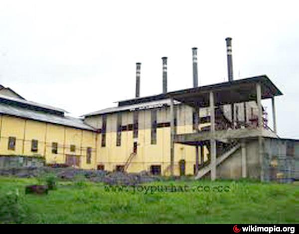
Manufactories Sugar mill, limestone and cement factory, coal factory, textile mill, pharmaceutical industry, rice mill, flour mill.
Cottage industries Loom 925, bamboo work 701, goldsmith 116, potteries 144, blacksmith 238, wood work 184, tailoring 630, welding 88.
NGO activities Operationally important NGOs are brac, CARE, proshika, asa, caritas, nijera kari, HEED Bangladesh, Seven Days Adventist Group, World Vision, thengamara mahila sabuj sangha, Joypurhat Palli Unnayan Abhijan, Abhash, Nido, Vaun, Jatiya Unnayan Sangstha and Jatiya Kalyan Sangstha.
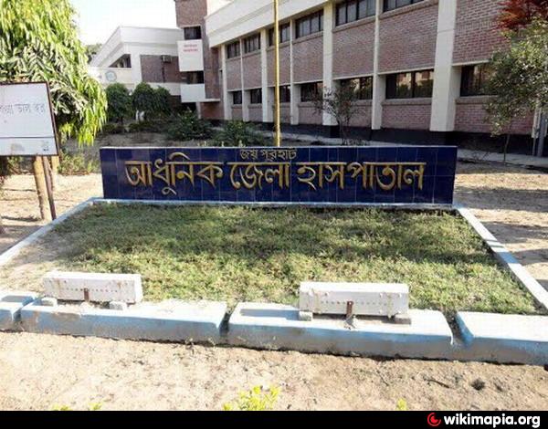
Health centres Modern district hospital 1, diabetic hospital 1, upazila health complex 5, union health centre 13, Red Crescent health centre 1, private clinic 5, veterinary hospital 1, upazila veterinary care centre 5.
The location of Joypurhat district town is 25.1004975N 89.0335387E. Joypurhat (Town) consists of 9 wards and 48 mahallas. The area of the town is 18.53 km. The town has a population of 56323; male 51.60%, female 48.40%. Literacy rate among the town people is 51.4%. It has a circuit house and a dakbungalow.Joypurhat (Town) consists of 9 wards and 48 mahallas. The area of the town is 18.53 km. The town has a population of 56323; male 51.60%, female 48.40%. Literacy rate among the town people is 51.4%. It has a circuit house and a dakbungalow.
Joypurhat was the only subdivision of the erstwhile Bogra district, and since 1984 it has been turned into a district. The district consists of 3 municipalities, 27 wards, 5 upazilas, 32 union parishads, 719 mouzas, 74 mahallas and 898 villages. The upazilas are joypurhat sadar, akkelpur, kalai, khetlal and panchbibi.
Archaeological heritage and relics: the Garuda Pillar at Bhimer Panti, Dargah of Nimai Pir.
As of the 1991 Bangladesh census, Population 844818; male 51.03%, female 48.97%; Muslim 88.18%, Hindu 9.57%, tribles and others 2.25%; ethnic nationals: Santal, Orao, Munda, Mahali, Koch, Pahan, Buna, Ho, Mahato, Rajbangshi and Koch are noted trible.
Religious institutions Mosque 1644, temple 104, church 9, mazar 6, sacred place 3.
Literacy and educational institutions Average literacy 19.8%; male 27.4% and female 11.8%. Educational institutions: government college 2, non-government college 15, junior school 13, law college 1, primary education training institute 1, vocational training institute 1, technical college 1, government high school 2, non-government high school 76, government primary school 209, non-government primary school 56, madrasa 83. Noted educational institutions: Kalai Mayen Uddin High School (1913), Sonamukhi High School (1916), Khanjanpur High School (1917), Khanjanpur Mission Girl's High School (1919), Karai Nurul Huda Aliya Madrasa (1926), Baniapara Madrasa (1936), Teghar High Madrasa (1939), Ramdeo Bajla Government High School (1946), Joypurhat Government College (1946).
Cultural organisations Library 7, club 224, cinema hall 15, women's organisation 75, theatre group 5, literary society 8, theatre place 1, shilpakala academy 1, co operative society 36.
Main occupations Agriculture 53.33%, agricultural labourer 24.85%, wage labourer 1.66%, commerce 9.95%, service 4.39%, transport 1.38%, others 7.44%.
Land use Cultivable land 80028 hectares, fallow land 20 hectares; single crop 5%, double crop 60% and treble crop land 35%; cultivable land under irrigation 85%.
Land control Among the peasants 11% are landless, 53.5% small, 21.8% intermediate and 13.7 rich; cultivable land per head 0.09 hectares.
Main crops: Paddy, potato, sugarcane, banana, jute, turmeric, mustard seed and vegetables.
Fisheries, dairy and poultries Dairy 325, poultry 362, fishery 1686, hatchery 9.
Communication facilities Roads: pucca 242 km, semi pucca 64.4 km and mud 1831.28 km; waterways 38 nautical mile; railways 45 km.
Manufactories Sugar mill, limestone and cement factory, coal factory, textile mill, pharmaceutical industry, rice mill, flour mill.
Cottage industries Loom 925, bamboo work 701, goldsmith 116, potteries 144, blacksmith 238, wood work 184, tailoring 630, welding 88.
NGO activities Operationally important NGOs are brac, CARE, proshika, asa, caritas, nijera kari, HEED Bangladesh, Seven Days Adventist Group, World Vision, thengamara mahila sabuj sangha, Joypurhat Palli Unnayan Abhijan, Abhash, Nido, Vaun, Jatiya Unnayan Sangstha and Jatiya Kalyan Sangstha.
Health centres Modern district hospital 1, diabetic hospital 1, upazila health complex 5, union health centre 13, Red Crescent health centre 1, private clinic 5, veterinary hospital 1, upazila veterinary care centre 5.
Nearby cities:
Coordinates: 25°6'44"N 89°0'53"E
- Gaibandha 54 km
- Gangarampur 70 km
- Buniadpur 78 km
- Rangpur 79 km
- Saidpur 80 km
- Malda 93 km
- Maynaguri 166 km
- Araria 200 km
- Forbesganj 224 km
- Darjeeling 236 km
- TALAB 6 km
- Paharpur 10 km
- Rajshahi Division 13 km
- Khetlal Upazila HQ 14 km
- Akkelpur Upazila HQ 16 km
- Kalai Upazila HQ 17 km
- Tilakpur Bazar, Akkelpur, Joypurhat 26 km
- Dhupchanchia Upazila HQ 31 km
- Gobindaganj Upazila 35 km
- Gaibandha District 56 km
Comments