Khetlal Upazila HQ
| township, subdistrict, fourth-level administrative division, local government
Bangladesh /
Jaipur Hat /
World
/ Bangladesh
/ Jaipur Hat
/ Jaipur Hat
World / Bangladesh / Rajshahi / Bogra / Jaipurhat
township, subdistrict, fourth-level administrative division, local government
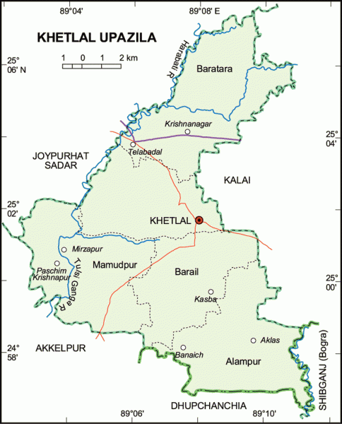

Khetlal Upazila (Joypurhat district) with an area of 142.60 sq km, is bounded by Joypurhat sadar upazila on the north, Akkelpur and Dupchanchia upazilas on the south, Kalai and Shibganj upazilas on the east, Joypurhat Sadar and Akkelpur upazilas on the west. Main river is Tulsiganga.
The location of Khetlal town is 25.0314993N 89.1279203E. Khetlal (Town) consists of one mouza. The area of the town is 9.43 sq km. The town has population of 10420; male 51.22%, female 48.78%. The density of population is 1105 per sq km. The literacy rate among the town people is 27.6%; male 33.8%, female 20.8%. The town has a dakbungalow.
Khetlal thana, now an upazila, was established in 1847. It consists of 5 union parishads, 88 mouzas, 155 villages.
As of the 1991 Bangladesh census, Population 106146; male 51.74%, female 48.26%. Muslim 89.40%, Hindu 9.04%, Chiristan 0.41%, Tribals and others 1.15%.
Religious institutions Mosque 225, temple 16, shrine 2.
Literacy and educational institutions Average literacy 25.2%; male 32.1%, female 17.5%. Educational institutions: college 1, high school 14, junior school 4, madrasa 11, government. primary school 34, non-government primary school 6. Noted educational institutions: Khetlal Pilot High School (1942).
Main occupations Agriculture 63.13%, agricultural labourer 19.61%, wage labourer 1.04%, transport 1.67%, commerce 7.07%, service 2.39%, others 5.09%.
Land use Cultivable land 12280 hectares, follow land 844 hectares; single crop 8%, double crop 68% and treble crop 24%. Under irrigation cultivable land is 98%.
Land control Among the peasants 15% are landless, 56% small, 24% intermediate and 5% rich; cultivable land per head 0.12 hectares.
Fisheries, dairies, poultries Fishery 11, dairy 141, poultry 69.
Communication facilities Roads: pucca 40 km, semi pucca 6 km, mud road 142 km; waterways 12 nautical mile.
Cottage industries Weaving 5, bamboo work 300, goldsmith 13, woodwork 17, sewing 130, blacksmith 31, potteries 160, welding 4.
NGO activities Operationally important NGOs are brac, asa, care.
Health centres Upazila health complex 1, family planning clinic 5.
Nearby cities:
Coordinates: 25°1'58"N 89°7'34"E
- Gobindaganj Upazila 24 km
- Shaghatta Upazila 43 km
- Sarishabari Upazila 65 km
- Bholahat Upazila HQ 95 km
- Abhaynagar Upazila HQ 221 km
- Fakirhat Upazila HQ 254 km
- Kachua Upazila HQ 273 km
- Koyra Upzila HQ 295 km
- Maidi Vdc 542 km
- Samote Union Council 1782 km
- gopinath pur bazaar 8.5 km
- TILAKPUR 12 km
- Jpypuhat Sugar Mills Administrative & Res Area 13 km
- Joypurhat Girls' Cadet College (JGCC) 14 km
- Paharpur 15 km
- Jogir Bhaban (Ancient Pundra City) 20 km
- TALAB 20 km
- Tilakpur Bazar, Akkelpur, Joypurhat 21 km
- Rajshahi Division 27 km
- Gaibandha District 54 km