Rangpur
Bangladesh /
Rangpur /
World
/ Bangladesh
/ Rangpur
/ Rangpur
World / Bangladesh / Rajshahi / Ranpur / Rongpur
town, second-level administrative division
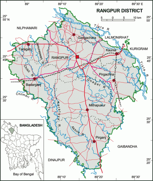
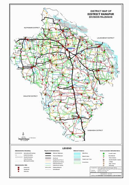
Rangpur District (Rangpur division- composed of eight districts of the northern Bangladesh) with an area of 2307.78 sq km, is bounded by Nilphamari district on the north, Gaibandha district on the south, Kurigram district on the east and Dinajpur district on the west. Main rivers are Tista, Jamuneshwari, Karatoya, Chikli and Ghaghat. About 80% area of the district is composed of alluvial soil of Tista basin and 20% Barind land. Annual average temperature: maximum 32.3°C, minimum 11.2°C; total rainfall 2931 mm.
Rangpur (Town) stands on the bank of the river Ghagat. It consists of 15 wards and 109 mahallas. The town was turned into a municipality in 1869. It has an area of 42.57 sq km. The population of the municipality is 251699; male 52.31%, female 47.69%. The density of population is 5913 per sq km. Literacy rate among the town people is 54.6%.
The district consists of three municipalities, eight upazilas, 33 wards, 84 union parishads, 2151 mouzas and 1519 villages 203 mahallas. The upazilas are Badarganj, Gangachara, Kaunia, Rangpur sadar, Mithapukur, Pirgachha, Pirganj and Taraganj; the municipalities are Rangpur Sadar, Badarganj and Kaunia.
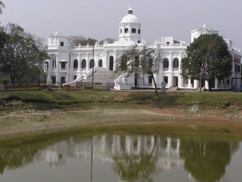
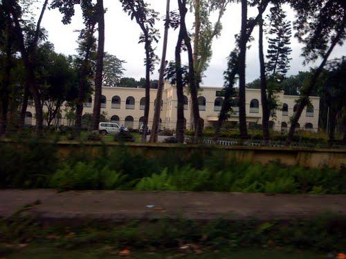
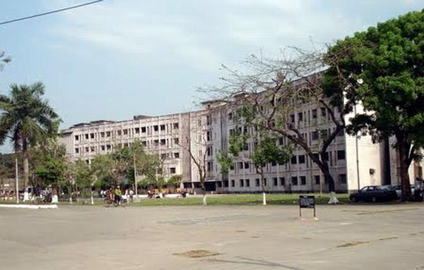
Heritage and relics: Tajhat Rajbari, Keramatia Mosque, tomb of the noted Islamic thinker Maulana Keramat Ali Jainpuri, tomb of Shah Jalal Bokheri at Mahiganj, tomb of Ismail Ghazi at Kataduar, carmichael college Building, home stead of roquiah sakhawat hossain at Pairabandh, Zila Parishad Building, Takka Mosque at Latifpur (Mughal period, Mithapukur upazila), three domed Jami Mosque at Mithapukur (Mughal period), four domed Taraganj Mosque, nine domed Radhanagar (Badarganj upazila) Mosque (Mughal period), tomb of Kutub Shah at Kutubpur, Vhim Garh at Manshinghpur (Badarganj upazila), Hari Mandir at Chandan Hat (Gangachara upazila) and Mitha Pukur (excavated during the Mughal period).
Historical events: Mughal commanders of Emperor Akbar, conquered part of Rangpur in 1575 and Rangpur came completely under the Mughal empire in 1686. Mughalbasa and Mughalhat of Kurigram district still bear marks of the Mughal rule in the region. Rangapur Ghoraghat has been mentioned in the book of Riyaz-us-Salatin. During the early period of the company rule fakir-sannyasi resistance and peasant rebellion were held in Rangpur.
Population 2534365: male 50.92%, female 49.08%; Muslim 89.60%, Hindu 9.59% and others 0.81%; ethnic nationals: Santal and Orao.
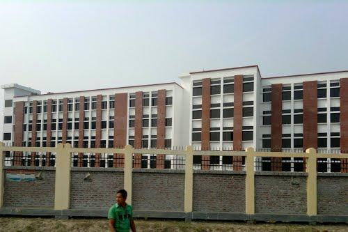
Average literacy 26.7%; male 33.5% and female 19.4%. Educational institutions: university college 1, college 64, medical college 1, technical college 1, teacher's training college 3, cadet college 1, polytechnic institute 1, vocational institute 1, law college 1, homeopath college 1, music school 1, high school 282, junior high school 38, madrasa 370, government primary school 722, non-government primary school 444, kindergarten 20, satellite school 44 and NGO operated school 193 and community school 20.
Main occupations Agriculture 40.26%, agricultural labourer 28.01%, wage labourer 4.88%, commerce 10.12%, service 5.56%, transport 2.11% and others 9.06%.
Manufacturing: Sugar mill, distilleries, rice, flour mill, saw mill, ice factory, oil mill, match factory, bidi factory, iron works, cold storage, printing press, lathe machine and welding.
Cottage industries: Weaving, bamboo work, goldsmith, blacksmith, potteries, wood work, tailoring and bidi.
Communication facilities Roads: pucca 570 km, semi pucca 109 km and mud road 4101 km; railways 71 km; waterways 30 nautical mile.
Health centres Medical college hospital 1, zila sadar hospital 1, TB hospital 1, TB clinic 1, eye hospital 1, family planning centre 80, union health centre 30, charitable dispensary 12, municipal medical centre 1, maternity and child welfare centre 1, satellite clinic 40.
NGO activities: Operationally important NGOs are brac, asa, grameen bank, CARE, RDRS, RDSS, proshika, Grameen Krishi Foundation, thengamara mahila sabuj sangha, Gram Bikash.
Rangpur (Town) stands on the bank of the river Ghagat. It consists of 15 wards and 109 mahallas. The town was turned into a municipality in 1869. It has an area of 42.57 sq km. The population of the municipality is 251699; male 52.31%, female 47.69%. The density of population is 5913 per sq km. Literacy rate among the town people is 54.6%.
The district consists of three municipalities, eight upazilas, 33 wards, 84 union parishads, 2151 mouzas and 1519 villages 203 mahallas. The upazilas are Badarganj, Gangachara, Kaunia, Rangpur sadar, Mithapukur, Pirgachha, Pirganj and Taraganj; the municipalities are Rangpur Sadar, Badarganj and Kaunia.
Heritage and relics: Tajhat Rajbari, Keramatia Mosque, tomb of the noted Islamic thinker Maulana Keramat Ali Jainpuri, tomb of Shah Jalal Bokheri at Mahiganj, tomb of Ismail Ghazi at Kataduar, carmichael college Building, home stead of roquiah sakhawat hossain at Pairabandh, Zila Parishad Building, Takka Mosque at Latifpur (Mughal period, Mithapukur upazila), three domed Jami Mosque at Mithapukur (Mughal period), four domed Taraganj Mosque, nine domed Radhanagar (Badarganj upazila) Mosque (Mughal period), tomb of Kutub Shah at Kutubpur, Vhim Garh at Manshinghpur (Badarganj upazila), Hari Mandir at Chandan Hat (Gangachara upazila) and Mitha Pukur (excavated during the Mughal period).
Historical events: Mughal commanders of Emperor Akbar, conquered part of Rangpur in 1575 and Rangpur came completely under the Mughal empire in 1686. Mughalbasa and Mughalhat of Kurigram district still bear marks of the Mughal rule in the region. Rangapur Ghoraghat has been mentioned in the book of Riyaz-us-Salatin. During the early period of the company rule fakir-sannyasi resistance and peasant rebellion were held in Rangpur.
Population 2534365: male 50.92%, female 49.08%; Muslim 89.60%, Hindu 9.59% and others 0.81%; ethnic nationals: Santal and Orao.
Average literacy 26.7%; male 33.5% and female 19.4%. Educational institutions: university college 1, college 64, medical college 1, technical college 1, teacher's training college 3, cadet college 1, polytechnic institute 1, vocational institute 1, law college 1, homeopath college 1, music school 1, high school 282, junior high school 38, madrasa 370, government primary school 722, non-government primary school 444, kindergarten 20, satellite school 44 and NGO operated school 193 and community school 20.
Main occupations Agriculture 40.26%, agricultural labourer 28.01%, wage labourer 4.88%, commerce 10.12%, service 5.56%, transport 2.11% and others 9.06%.
Manufacturing: Sugar mill, distilleries, rice, flour mill, saw mill, ice factory, oil mill, match factory, bidi factory, iron works, cold storage, printing press, lathe machine and welding.
Cottage industries: Weaving, bamboo work, goldsmith, blacksmith, potteries, wood work, tailoring and bidi.
Communication facilities Roads: pucca 570 km, semi pucca 109 km and mud road 4101 km; railways 71 km; waterways 30 nautical mile.
Health centres Medical college hospital 1, zila sadar hospital 1, TB hospital 1, TB clinic 1, eye hospital 1, family planning centre 80, union health centre 30, charitable dispensary 12, municipal medical centre 1, maternity and child welfare centre 1, satellite clinic 40.
NGO activities: Operationally important NGOs are brac, asa, grameen bank, CARE, RDRS, RDSS, proshika, Grameen Krishi Foundation, thengamara mahila sabuj sangha, Gram Bikash.
Nearby cities:
Coordinates: 25°44'33"N 89°14'42"E
- Hat District 3998 km
- Al-Ghaydah District 4025 km
- Rumah District 4075 km
- Man'ar District 4183 km
- Thamud District 4186 km
- Al-Masilah District 4224 km
- Al-Qaf District 4288 km
- Zamakh wa Manwakh District 4436 km
- Marib District 4678 km
- Khabb wa ash-Sha'af District 4688 km
- Ganeshpur 0.5 km
- Babukha 1.3 km
- Dhap 2.9 km
- Rangpur Cantonment 3.3 km
- upashar 4.6 km
- Niamat concil 5.2 km
- চৌদ্দ ভূবন বিল 12 km
- Rangpur District 13 km
- Lalmonirhat District 42 km
- Rajshahi Division 65 km
Comments