Site of the USS Mount Hood (AE-11) Explosion
Papua New Guinea /
Manus /
Lorengau /
World
/ Papua New Guinea
/ Manus
/ Lorengau
World / Papua New Guinea / Manus
Second World War 1939-1945, military, explosion site, shipwreck, United States Navy


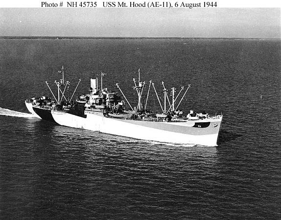


At approximately 08:55am on November 10th, 1944 the USS Mount Hood, the lead ship of her class of Ammunition Ships, exploded at this location while discharging ammunition.
The Mount Hood was little over 4 months old at the time of the accident, and had just completed her maiden voyage from North Carolina with a hold full of shells and explosives bound for the upcoming Phillipine Invasion. The detonation involved the ships full load of 3,800 tons of explosives, carved a trench 1000 feet long, 200 feet wide, and 30 to 40 feet deep in the ocean floor and left no trace of the Mount Hood larger than a 16x10ft piece of hull plating. The entire 267-man crew of the Mount Hood (save 18 who had gone ashore moments before the explosion) were never seen again.
Following the explosion, Seeadler Harbor was bedlam. Nine medium landing craft and a pontoon barge which were moored alongside Mount Hood were also obliterated by the explosion, along with their crews. The repair ship USS Mindanao (ARG-3), moored broadside to the Mount Hood 300 yards away, was decimated by shrapnel from the explosion with 180 of her crew killed or wounded by the blast. 17 other ships of the US Navy were damaged by either the shock wave or the shrapnel from the blast, or both, and 22 small craft were put out of action or sunk from the damage they received.
Lacking survivor testimony and any major pieces of evidence that would point to a cause for the explosion, a US Naval Review Board was unable to ascertain why the Mount Hood and her crew suffered such a catastrophic end.
www.navsource.org/archives/09/05/0511.htm
Wikipedia article: http://en.wikipedia.org/wiki/USS_Mount_Hood_(AE-11)
Nearby cities:
Coordinates: 2°1'42"S 147°21'17"E
- Tsili Tsili Airfield (Site) 547 km
- Crash site of B26 40-1426 of 22nd Bomb Group USAAF, shot down 2 May 1942 850 km
- Site of the Battle of Milne Bay (1942) 980 km
- Frans Kaisiepo Airport 1258 km
- Munda 1301 km
- Ironbottom Sound 1550 km
- Wreck of USS Hornet (CV-8) 2263 km
- Smirnoff Beach 3213 km
- Temora Airport (former WW2 RAAF Base) 3605 km
- Koo-wee-rup airfield (former WW2 RAAF airfield) 4031 km
- Los Negros Island 2.5 km
- Lou Island 42 km
- St. Andrew Strait Volcano 46 km
- Tong Island 46 km
- Horno Islands 49 km
- Manus Island 50 km
- Soku Reef 51 km
- Manus Province 54 km
- Rambutyo Island 57 km
- Purdy Islands 147 km