Upper Las Virgenes Canyon Open Space Preserve
USA /
California /
Agoura Hills /
Victory Blvd. trailhead
World
/ USA
/ California
/ Agoura Hills
World / United States / California
park, nature conservation park / area, movie / film / TV location
Formerly known as Ahmanson Ranch and once used for pasturing cattle and sheep, unsuccessful oil drilling, and movie filming, the land here was part of the Spanish land grant Rancho San José de Gracia (aka Simí grant), originally conferred by the King of Spain in 1795 and 1821 to brothers Francisco Javier, Miguel, and Patricio Pico. Rancho Simí was later owned by José de la Guerra y Noriega in 1842.
The land continued to pass hands until 1914 when it was acquired by the Jesse L. Lasky Feature Play Company. Cecil B. DeMille filmed the lavish "Rose of the Rancho" here in 1914, using almost all of the property in some form or another. A stock farm was maintained here for the movie, and some 500 people in all were used in filming. Other movies filmed here include They Died with Their Boots On, Gone with the Wind (the scene where Scarlett O'Hara vows to never go hungry again was filmed here), Duel in the Sun, The Charge of the Light Brigade, Thundering Herd, and more.
In 1963, Home Savings of America purchased the now disused property, calling it Ahmanson Ranch, with ideas of developing it. These plans didn't pan out, and it wasn't until 1986 that development plans were again discussed. In 1992, a huge development plan was approved that would have seen the property levelled for a master planned community. In the meantime, Home Savings of America was purchased by Washington Mutual Company in 1998, giving WaMu control of the property.
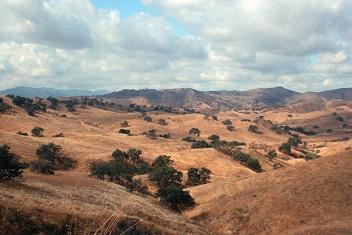
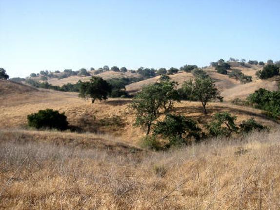
After 17 years of fierce campaigning by activists at the local, state, and federal levels, 2,983 acres of sensitive habitat was spared from development when it was sold by WaMu to the State of California in 2003. Plans originally called for its transformation into Ahmanson City, which was to include eight years worth of grading to flatten enough ground for some 3,000+ homes, two golf courses, and over 400,000 square feet of commerical and residential space. With the land's transformation into open space, over 1000 mature California oak trees were saved along with habitat for threatened California red-legged frogs, endangered Least Bell's vireos, endangered Southwestern willow flycatchers, and San Fernando Valley spineflower (once thought to be extinct).
The newly acquired 2,983-acre property was annexed with the existing 2,650-acre Upper Las Virgenes Open Space Park, and the combined 5,633-acre public parkland was renamed Upper Las Virgenes Canyon Open Space Preserve in 2004.
www.ahmanson.org
www.moviesites.org/laskymesa.htm
www.lamountains.com/parks.asp?parkid=28
The land continued to pass hands until 1914 when it was acquired by the Jesse L. Lasky Feature Play Company. Cecil B. DeMille filmed the lavish "Rose of the Rancho" here in 1914, using almost all of the property in some form or another. A stock farm was maintained here for the movie, and some 500 people in all were used in filming. Other movies filmed here include They Died with Their Boots On, Gone with the Wind (the scene where Scarlett O'Hara vows to never go hungry again was filmed here), Duel in the Sun, The Charge of the Light Brigade, Thundering Herd, and more.
In 1963, Home Savings of America purchased the now disused property, calling it Ahmanson Ranch, with ideas of developing it. These plans didn't pan out, and it wasn't until 1986 that development plans were again discussed. In 1992, a huge development plan was approved that would have seen the property levelled for a master planned community. In the meantime, Home Savings of America was purchased by Washington Mutual Company in 1998, giving WaMu control of the property.
After 17 years of fierce campaigning by activists at the local, state, and federal levels, 2,983 acres of sensitive habitat was spared from development when it was sold by WaMu to the State of California in 2003. Plans originally called for its transformation into Ahmanson City, which was to include eight years worth of grading to flatten enough ground for some 3,000+ homes, two golf courses, and over 400,000 square feet of commerical and residential space. With the land's transformation into open space, over 1000 mature California oak trees were saved along with habitat for threatened California red-legged frogs, endangered Least Bell's vireos, endangered Southwestern willow flycatchers, and San Fernando Valley spineflower (once thought to be extinct).
The newly acquired 2,983-acre property was annexed with the existing 2,650-acre Upper Las Virgenes Open Space Park, and the combined 5,633-acre public parkland was renamed Upper Las Virgenes Canyon Open Space Preserve in 2004.
www.ahmanson.org
www.moviesites.org/laskymesa.htm
www.lamountains.com/parks.asp?parkid=28
Wikipedia article: http://en.wikipedia.org/wiki/Upper_Las_Virgenes_Canyon_Open_Space_Preserve
Nearby cities:
Coordinates: 34°11'11"N 118°42'32"W
- Cheeseboro Canyon + Palo Commado Canyon Parks 7.7 km
- Topanga State Park 8 km
- Chatsworth Nature Preserve and Reservoir (site) 8.2 km
- Malibu Creek State Park/20th Century Fox Ranch 9 km
- Santa Susana Pass State Historical Park 12 km
- Indian Springs Open Space Park 15 km
- Solstice Canyon 15 km
- Rocky Peak Park 17 km
- Sepulveda Basin Recreation Area 18 km
- Will Rogers Beach State Park 22 km
- Bell Canyon, California 2.8 km
- Mountain View Estates 3.7 km
- SSFL-South Buffer Zone 4.1 km
- Rocketdyne Santa Susana Field Laboratory (SSFL) 4.7 km
- SSFL - Test AREA FOUR 4.9 km
- SSFL - Test AREA TWO 5.1 km
- SSFL - Test AREA ONE 5.8 km
- Runkle Canyon 6.2 km
- West Hills 7.2 km
- Woodland Hills 9 km
Comments