Snyder County, Pennsylvania
USA /
Pennsylvania /
Paxtonville /
World
/ USA
/ Pennsylvania
/ Paxtonville
World / United States / Pennsylvania
county, draw only border
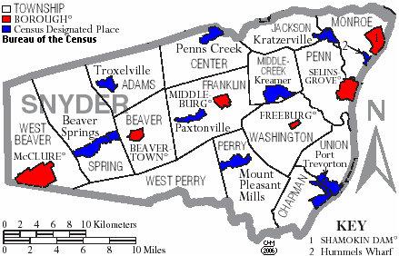
Snyder County is located in central Pennsylvania, bordered by the Susquehanna River on the east. There are fifteen townships and six boroughs within Snyder County. Its 332 square miles (211,000 acres) are located in the Valley and Ridge physiographic province. Mountains and steep hills make up most of the county, but some broad, sloping or nearly level areas can be found in the county's central valleys and along the Susquehanna River. At least half of the county (112,000 acres) is forested.
As of 2010, the population was 39,702. Snyder County was formed in 1855 from parts of Union County. The county seat is Middleburg
www.livingplaces.com/PA/Snyder_County.html
As of 2010, the population was 39,702. Snyder County was formed in 1855 from parts of Union County. The county seat is Middleburg
www.livingplaces.com/PA/Snyder_County.html
Wikipedia article: http://en.wikipedia.org/wiki/Snyder_County,_Pennsylvania
Nearby cities:
Coordinates: 40°45'45"N 77°4'39"W
- Lancaster County, Pennsylvania 58 km
- Centre County, Pennsylvania 122 km
- Dorchester County, Maryland 236 km
- Suffolk County, New York 306 km
- Accomack County, Virginia 314 km
- Dare County, North Carolina 513 km
- Hyde County, North Carolina 564 km
- Craven County, North Carolina 596 km
- Carteret County, North Carolina 618 km
- Columbus County, North Carolina 721 km
- Penns Creek, Pennsylvania 11 km
- Beaver Springs, Pennsylvania 13 km
- Limestone Township 15 km
- Mifflinburg, Pennsylvania 18 km
- Snyder Middleswarth Natural Area 18 km
- McClure, Pennsylvania 21 km
- Lewis Township 22 km
- Hartley Township 23 km
- Buffalo Township 24 km
- West Buffalo Township 26 km