Hawthorne Grill (site) (Hawthorne, California)
USA /
California /
Hawthorne /
Hawthorne, California
World
/ USA
/ California
/ Hawthorne
World / United States / California
movie / film / TV location, historical layer / disappeared object
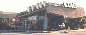
The presumed old location of the coffee shop in Pulp Fiction (1994). It was demolished after shooting. This is a correction of the other entry just north of this one.
a) See pictures on www.hawthornegrill.com. There is a street and STOP sign north of the coffee shop so the correct location was south of the side street (West 137th Pl) instead of north of it.
b) In the Pulp Fiction DVD, you can see three large trees on Hawthorne Blvd right outside the coffee shop windows during Pumpkin's and Honey Bunny's conversation. These are also clearly visible on the satellite map, just south of West 137th Pl.
c) During the hold-up at the end of the film (when the Tim Roth character points the gun at manager) you can better see the open area just north of the coffee shop and the roof which has now been pulled down. The location of the 3 pillars are still visible on the satellite picture.
Please check your Pulp Fiction DVD.
Wikipedia article: http://en.wikipedia.org/wiki/Pulp_Fiction_(film)
Nearby cities:
Coordinates: 33°54'24"N 118°21'10"W
- McDonnell Douglas Aircraft / Harvey Aluminum Plant (former site) 6.8 km
- LAX Reclaimed Neighborhoods 10 km
- Lopez Ranch 11 km
- Old Hughes Aircraft Plant and Runway (Westchester area now called Playa Vista) 11 km
- Lions Drag Strip (site) 15 km
- Cheli Air Force Station (site) 19 km
- Industrial development area, 1920s 19 km
- site of North American- Rockwell Downey plant and Vultree Aircraft. 20 km
- Aircraft Manufacturing Plant 20 km
- Simons Brick Company Plant Number 3 (1905-1953) 22 km
- Leuzinger High School 0.8 km
- Billy Mitchell Elementary School 1 km
- Wiseburn, California 1.2 km
- Jane Addams Middle School 1.6 km
- Lawndale High School 1.6 km
- Rogers Middle School / Anderson Elementary School 2 km
- Marco Polo Express 2.2 km
- DHL 2.2 km
- South Bay 6.3 km
- Los Angeles County, California 40 km