Hambledon Hill
United Kingdom /
England /
Sturminster Newton /
World
/ United Kingdom
/ England
/ Sturminster Newton
World / United Kingdom / England
neolithic age, hillfort, iron age
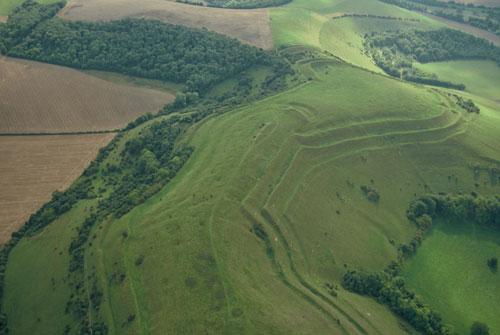

This magnificent Iron Age hillfort conceals traces of earlier periods. There are two Neolithic causewayed enclosures, one in the central part and a smaller one on the south-eastern spur of the hill, and a long barrow, 73m long, in the middle section . The hillfort is encircled by double ramparts and on the south-east, a double ditch was built to increase the defences.
Wikipedia article: http://en.wikipedia.org/wiki/Hambledon_Hill
Nearby cities:
Coordinates: 50°54'46"N 2°13'22"W
- Whitesheet Hill 24 km
- Ham Hill 37 km
- Brent Knoll 65 km
- Brean Down 73 km
- Beacon Hill 76 km
- Ivinghoe Beacon 153 km
- Breidden Fort 210 km
- Stanwick Iron Age Fortifications 401 km
- Eildon Hill(s) 522 km
- Traprain Law 563 km
- Stepleton House - grounds 2.4 km
- Clayesmore School - grounds 2.8 km
- Bryanston School 6 km
- Hammetts Farm 6.7 km
- Blandford Camp 8.7 km
- Downlands Primary School 8.7 km
- Athletic Ground 8.9 km
- Ashley Wood Golf Course 10 km
- Cranborne Chase AONB 15 km
- Dorset 15 km