Mount Semeru 3676 m
| mountain, volcano, interesting place, mountaineering
Indonesia /
Jawa Timur /
Dampit /
World
/ Indonesia
/ Jawa Timur
/ Dampit
World / Indonesia / Jawa Timur
mountain, volcano, interesting place, mountaineering


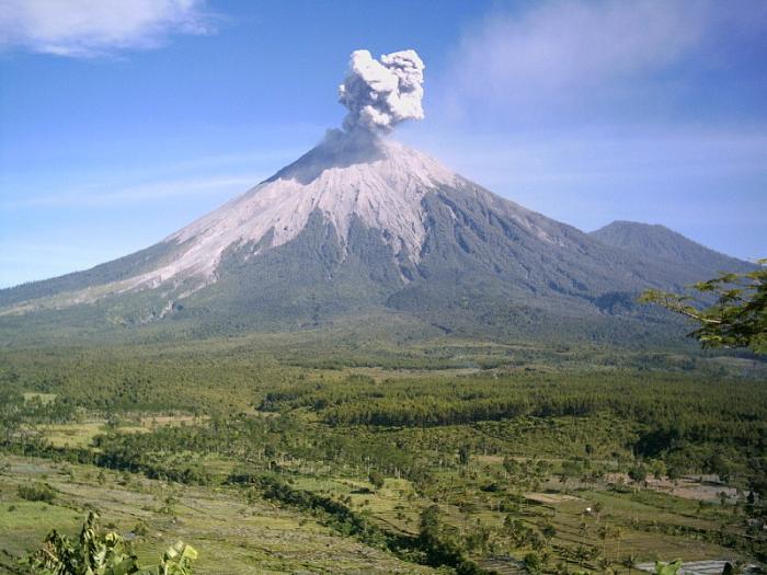
Semeru, the highest volcano on Java, and one of its most active, lies at the southern end of a volcanic massif extending north to the Tengger caldera. The steep-sided volcano, also referred to as rises abruptly to 3676 m above coastal plains to the south. Mount Semeru was constructed south of the overlapping Ajek-ajek and Jambangan calderas. A line of lake-filled maars was constructed along a N-S trend cutting through the summit, and cinder cones and lava domes occupy the eastern and NE flanks. Summit topography is complicated by the shifting of craters from NW to SE. Frequent 19th and 20th century eruptions were dominated by small-to-moderate explosions from the summit crater, with occasional lava flows and larger explosive eruptions accompanied by pyroclastic flows that have reached the lower flanks of the volcano. Semeru has been in almost continuous eruption since 1967.
Wikipedia article: http://en.wikipedia.org/wiki/Semeru
Nearby cities:
Coordinates: 8°6'43"S 112°55'28"E
- Iyang-Argapura Mountains Complex 71 km
- Baluran Volcano 1,274 m 160 km
- West Bali National Park 166 km
- Batur Caldera 264 km
- Mount Agung (3142 m) 281 km
- Mount Punikan 360 km
- Gunung Rinjani National Park 368 km
- Mount Rinjani (3726 m) 380 km
- Sangenges Ancient Volcano 459 km
- Mount Tambora 555 km
- Cemoro Kandang 5.1 km
- Savana Oro-oro Ombo 5.9 km
- Bromo-Tengger-Semeru National Park 8.5 km
- Desa Rowo Baung 10 km
- Semeru's Survivors Residence 10 km
- Pasrujambe District 11 km
- Pronojiwo District 12 km
- Desa Mulyoasri 12 km
- Candipuro District 13 km
- Senduro District 18 km
Comments