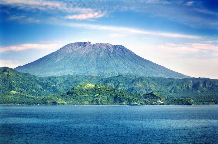
Mount Agung (3142 m)
Indonesia /
Bali /
Karangasem /
World
/ Indonesia
/ Bali
/ Karangasem
World / Indonesia / Bali
mountain, volcano, stratovolcano, invisible


3142m tall.
Last eruption: march 1963
www.volcano.si.edu/world/volcano.cfm?vnum=0604-02=
Symmetrical Agung stratovolcano, Bali's highest and most sacred mountain, towers over the eastern end of the island. The volcano, whose name means "Paramount," rises above the SE caldera rim of neighboring Batur volcano, and the northern and southern flanks of Agung extend to the coast. The 3142-m-high summit of Agung contains a steep-walled, 500-m-wide, 200-m-deep crater. The flank cone Pawon is located low on the SE side of Gunung Agung. Only a few eruptions dating back to the early 19th century have been recorded from Agung in historical time. Agung's 1963-64 eruption, one of the world's largest of the 20th century, produced voluminous ashfall and devastating pyroclastic flows and lahars that caused extensive damage and many fatalities.
Elevation: 3,031 m (9,944 ft)
Prominence: 3.031 m
Isolations: 105 kilometres (65 mi)
Type: Stratovolcano
Listing: Island high point / Ultra Ribu
Erupted: 1808, 1843, 1963-64, Sept 2017
Ranked 87th highest in the world (peaks by prominence)
Wikipedia article: http://en.wikipedia.org/wiki/Mount_Agung
Nearby cities:
Coordinates: 8°20'34"S 115°30'26"E
- Batur Caldera 27 km
- Mount Punikan 74 km
- Gunung Rinjani National Park 84 km
- Mount Rinjani (3726 m) 94 km
- Mount Samalas / Old Rinjani's Collapsed Peak (Erupted 1257) 96 km
- West Bali National Park 122 km
- Baluran Volcano 1,274 m 141 km
- Sangenges Ancient Volcano 174 km
- Iyang-Argapura Mountains Complex 221 km
- Mount Tambora 270 km
- Mount Agung Crater
- Karangasem Regency 5.3 km
- Mount Paon 6.8 km
- Desa Datah 10 km
- BALI ACARDANIA SKDANA 10 km
- Scuba Seraya Resort 11 km
- Amed port 13 km
- Baturinggit Beach 13 km
- Lombok Strait 45 km
- Bali 50 km
Comments