Al-Hasakah
Syria /
al-Hhasakah /
World
/ Syria
/ al-Hhasakah
/ al-Hhasakah
, 2 km from center (الحسكة)
World / Syria / Al Ḥasakah
city, capital city of state/province/region
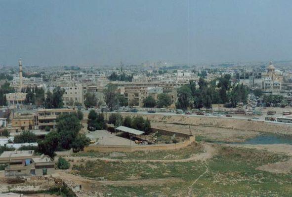


Al-Hasakah (Arabic: الحسكة, also الحسجة in some local bedouin dialects; Turkish: Hasiçi; Kurdish: Heseke or Hesîçe; Syriac: ܚܣܟܗ), is the biggest city in Cizire Canton and Rojava (former the capital city of Al-Hasakah Governorate). Center of the Hasaka subdistrict of Hasaka district of Hasaka governorate.
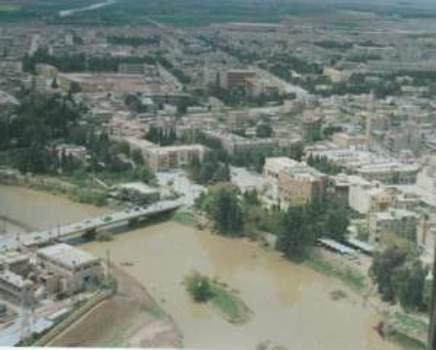
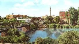
With a population of 188,160 (251,570 in the metropolitan area) residents, Al-Hasakah is among the 10 largest cities in Syria. Al-Hasakah has a mixed population with the majority being Arabs and Kurds in addition to a significant large number of Assyrians and a smaller number of Armenians. The Khabur River runs through Al-Hasakah and the rest of the governorate.
The city of Al-Hasakah is divided into 5 districts, which are Al-Madinah (30,436), Al-Aziziyah ( 56,123), Ghuwayran (34,191), Al-Nasra (42.070) and Al-Nashwa (25,340). These districts, in turn, are divided into 29 neighborhoods. The majority of the population is Kurdish (about 120,000), with a big Arab minority (about 60,000) and a small Assyrian and Armenian minority (about 5,000?).
Al-Hasakah is surrounded by several prehistoric settlement mounds. The best known are Tell Brak, 45 kilometers north-east and Tell Knedig, 20 kilometers to the south.
In Ottoman times the town was insignificant. Today's settlement was established in April 1922 by a French military post. After the expulsion and genocide of the Armenians in the then Ottoman Empire many refugees fled to the city and began to develop it in the 1920s. During the French mandate period, Assyrians, fleeing ethnic cleanings in Iraq during the Simele massacre, established numerous villages along the Khabur River during the 1930s. French troops were stationed on the Citadel Hill during that time. In 1942 there were 7,835 inhabitants in al-Hasakah, several schools, two churches and a gas station. The new city grew from the 1950s to the administrative center of the region. The economic boom of the cities Qamishli and al-Hasakah was a result of the irrigation projects started in the 1960s which transformed the Northeast of Syria into the main cotton-growing area. The 1970s brought oil production from the oil fields of Qara Shuk and Rumaylan in the extreme northeast.
In 2007-2008, Syrian archaeologists excavated the 2.5-acre citadel hill in the city center. They found a layer of mud-brick walls dating to the Neo-Assyrian period of the 11th to the 8th century BCE, and the remains of a Byzantine church dating from the 5th century. In the overlying layers they found traces of settlement from the early Islamic period.
Hasakah is jointly controlled by the Syrian Army, and Kurds and their allies during the Syrian Civil War. Since August 2014 ISIS have besieged the city, having failed to enter it earlier. In June 2015, ISIS entered the city, but was pushed out by Syrian Army and Kurdish forces.
Hasakah city was liberated by YPG forces on 28/07/2015. Hundreds of "Islamic State" terrorists were killed. Lots of weapons and equipments, including tanks were seized.
A pocket of Regime forces (SAA and NDF) remains in the Center and in Gweran district:
wikimapia.org/#lang=pt&lat=36.512396&lon=40.733528&z=1...
Wikipedia article: http://en.wikipedia.org/wiki/Al_Hasakah
Nearby cities:
Coordinates: 36°30'13"N 40°44'47"E
- Mosul City 205 km
- Erbil City 265 km
- Erbil City 285 km
- Kirkuk 337 km
- Ramadi 404 km
- Saqlawiyah 429 km
- Baghdad City 458 km
- Karbala 517 km
- Al-Hillah 554 km
- Najaf 590 km
- Al-Wista (Center) 0.2 km
- Al-Malaab al-Baladi 0.4 km
- City Centre 0.4 km
- Al-Matar al-Shamali 0.9 km
- Salehiyê 1 km
- Aziziyê 1.9 km
- Al-Nashwa 2.4 km
- Al-Nasra 2.5 km
- Hasakah district 37 km
- Hassakah Governorate (PCS) 41 km
Comments