MNRR / Amtrak New Haven Union Station (New Haven, Connecticut)
USA /
Connecticut /
New Haven /
New Haven, Connecticut /
Union Avenue, 50
World
/ USA
/ Connecticut
/ New Haven
World / United States / Connecticut
train, railway, Amtrak, Metro-North Railroad, train station


Served by MNRR New Haven Line, Shore Line East & Amtrak. Large rail yard & refit facilities for Shore Line East & MNRR rollingstock.
Transfer point for:
Shore Line East to New London
www.shorelineeast.com/
en.wikipedia.org/wiki/Shore_Line_East
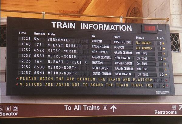
Union Station is on Amtrak's Northeast Corridor, and Acela, Regional and the Vermonter passenger trains use this station.
en.wikipedia.org/wiki/Acela_Express
en.wikipedia.org/wiki/Regional_%28Amtrak%29
en.wikipedia.org/wiki/Vermonter
www.amtrak.com/servlet/ContentServer?pagename=Amtrak/am...
www.trainweb.org/usarail/newhaven.htm
New Haven used to be the end/beginning of Electrified Overhead Catenary on the Northeast Corridor until the New Haven to Boston section was electrified for Amtrak's Acela Express.
as0.mta.info/mnr/stations/station_detail.cfm?key=252
Transfer point for:
Shore Line East to New London
www.shorelineeast.com/
en.wikipedia.org/wiki/Shore_Line_East
Union Station is on Amtrak's Northeast Corridor, and Acela, Regional and the Vermonter passenger trains use this station.
en.wikipedia.org/wiki/Acela_Express
en.wikipedia.org/wiki/Regional_%28Amtrak%29
en.wikipedia.org/wiki/Vermonter
www.amtrak.com/servlet/ContentServer?pagename=Amtrak/am...
www.trainweb.org/usarail/newhaven.htm
New Haven used to be the end/beginning of Electrified Overhead Catenary on the Northeast Corridor until the New Haven to Boston section was electrified for Amtrak's Acela Express.
as0.mta.info/mnr/stations/station_detail.cfm?key=252
Wikipedia article: http://en.wikipedia.org/wiki/Union_Station_(New_Haven)
Nearby cities:
Coordinates: 41°17'51"N 72°55'32"W
- Abandoned ROW of Southern New England Railroad 112 km
- Standard Steel 398 km
- North Carolina Transportation Museum 904 km
- CSX Queensgate Yard 1015 km
- Muskego Yard 1253 km
- Norfolk Southern's John Whitaker Intermodal Terminal 1326 km
- Sabana De Parra, Capital Del Municipio Paez, Estado Yaracuy 3490 km
- Thornton Tunnel (South End) 3946 km
- Sierra Railroad 4081 km
- Sacramento Northern Railway (abandoned) 4155 km
- The Hill 1.1 km
- Fair Haven 2.9 km
- East Rock Neighborhood 3.1 km
- Fair Haven Heights 3.7 km
- Tweed New Haven Regional Airport (HVN) 5 km
- East Haven, Connecticut 5.7 km
- Lake Saltonstall 6.4 km
- New Haven Regional Water Company Property 7 km
- New Haven County, Connecticut 11 km
- Long Island Sound 33 km