Bohol (Nueva Fuerza)
Philippines /
Central Visayas /
Nueva Fuerza
World
/ Philippines
/ Central Visayas
/ Nueva Fuerza
province, invisible, second-level administrative division

Bohol /bɔːhɔːl/ is a 1st provincial income class island province of the Philippines located in the Central Visayas region, consisting of the island itself and 75 minor surrounding islands. Its capital is Tagbilaran. With a land area of 4,821 km2 (1,861 sq mi) and a coastline 261 km (162 mi) long, Bohol is the tenth largest island of the Philippines. To the west of Bohol is Cebu, to the northeast is the island of Leyte and to the south, across the Bohol Sea, is Mindanao.
The province of Bohol is a first-class province divided into 3 congressional districts, comprising 1 component city and 47 municipalities. It has 1,109 barangays.
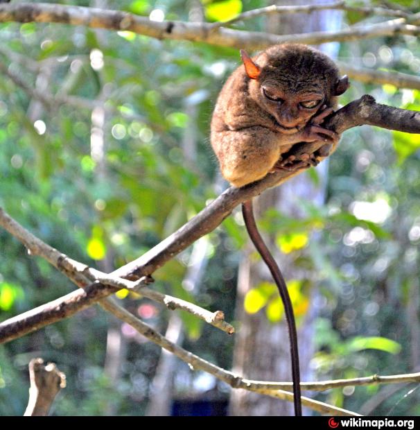
The province is a popular tourist destination with its beaches and resorts. The Chocolate Hills, numerous mounds of brown-coloured limestone formations, are the most popular attraction. The formations can be seen by land (climbing the highest point) or by air via ultralight air tours. Panglao Island, located just southwest of Tagbilaran, is famous for its diving locations and is routinely listed as one of the top ten diving locations in the world. Numerous tourist resorts and dive centers dot the southern beaches. The Philippine tarsier, amongst the world's smallest primates, is indigenous to the island.
A strait separates Bohol from Cebu, and both island provinces share a common language, but the Boholanos retain a conscious distinction from the Cebuanos. Bohol's climate is generally dry, with maximum rainfall between the months of June and October. The interior is cooler than the coast.
It was the home province of Carlos P. Garcia, the eighth president of the Republic of the Philippines (1957–1961) who was born in Talibon, Bohol.
On 15 October 2013, Bohol was devastated by a 7.2 magnitude earthquake whose epicenter was 6 km (3.7 mi) south of Sagbayan town. The earthquake, which also hit southern Cebu, claimed 156 lives altogether and injured 374 people. It also destroyed or damaged a number of Bohol's heritage churches.
In 2017, the provincial government began initiating the nomination of the entire province to the UNESCO Global Geoparks Network.
Google panorama: goo.gl/maps/vB5Jhvi5GTi5FQn99
The province of Bohol is a first-class province divided into 3 congressional districts, comprising 1 component city and 47 municipalities. It has 1,109 barangays.
The province is a popular tourist destination with its beaches and resorts. The Chocolate Hills, numerous mounds of brown-coloured limestone formations, are the most popular attraction. The formations can be seen by land (climbing the highest point) or by air via ultralight air tours. Panglao Island, located just southwest of Tagbilaran, is famous for its diving locations and is routinely listed as one of the top ten diving locations in the world. Numerous tourist resorts and dive centers dot the southern beaches. The Philippine tarsier, amongst the world's smallest primates, is indigenous to the island.
A strait separates Bohol from Cebu, and both island provinces share a common language, but the Boholanos retain a conscious distinction from the Cebuanos. Bohol's climate is generally dry, with maximum rainfall between the months of June and October. The interior is cooler than the coast.
It was the home province of Carlos P. Garcia, the eighth president of the Republic of the Philippines (1957–1961) who was born in Talibon, Bohol.
On 15 October 2013, Bohol was devastated by a 7.2 magnitude earthquake whose epicenter was 6 km (3.7 mi) south of Sagbayan town. The earthquake, which also hit southern Cebu, claimed 156 lives altogether and injured 374 people. It also destroyed or damaged a number of Bohol's heritage churches.
In 2017, the provincial government began initiating the nomination of the entire province to the UNESCO Global Geoparks Network.
Google panorama: goo.gl/maps/vB5Jhvi5GTi5FQn99
Wikipedia article: http://en.wikipedia.org/wiki/Bohol
Nearby cities:
Coordinates: 9°51'14"N 124°10'15"E
- East Kalimantan 1303 km
- Papua 1716 km
- Punjab Province 6178 km
- Balochistan Province 6927 km
- Kerman Province 7532 km
- Riyadh Province 8754 km
- Northern Borders Region 9092 km
- Mahajanga Province 9245 km
- Toliara Province 9419 km
- Saskatchewan 10915 km
- Chocolate Hills 1.5 km
- Palm Oil Plant 3.6 km
- Villaflor Elementary School 4.9 km
- Mount Pinoonan 5.3 km
- Chocolate Hills View Deck 6.2 km
- Hill 6.4 km
- Can-oling, Dagohoy 8.2 km
- Cemetery 8.9 km
- EAT Danao 11 km
- Danao Central Elementary School 11 km
Comments