Assumed wall perimeter of Damascus in roman times (Damascus)
Syria /
Damaskus /
Damascus
World
/ Syria
/ Damaskus
/ Damascus
, 1 km from center (دمشق)
World / Syria / Rif Dimashq
invisible
Add category
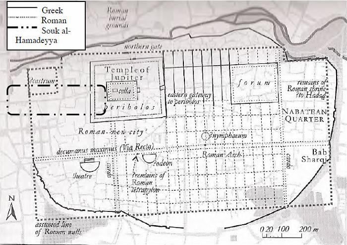
According to Arab sources the roman city had 7 gates. In the Arab Middle ages were maden some realignments, which still can be seen in any aerial view of the city. The section between the Gate of Safety (Bab as-Salama) and Thomas Gate (Bab Touma) is the best preserved part of the wall.
Image and information from: Damascus: A History (2005), written by Ross Burns
Image and information from: Damascus: A History (2005), written by Ross Burns
According to Arab sources the roman city had 7 gates. In the Arab Middle ages were maden some realignments, which still can be seen in any aerial view of the city. The section between the Gate of Safety (Bab as-Salama) and Thomas Gate (Bab Touma) is the best preserved part of the wall.
Image and information from: Damascus: A History (2005), written by Ross Burns
Nearby cities:
Coordinates: 33°30'31"N 36°18'55"E
- Mount Hermon/Jebel al-Shaykh 65 km
- Shouf District 91 km
- Nabatiyeh Governorate 93 km
- Batroun District 111 km
- South Lebanon Governorate 113 km
- al-Qalamoun Mountains/Northern Anti-Lebanon 113 km
- Mount Lebanon Governorate 116 km
- Block 7 136 km
- Block 4 149 km
- Hassakah Governorate 696 km
- Al-Amin 0.2 km
- Al Qaymariyah 0.5 km
- Bab Sharqi 0.5 km
- Old Damascus 0.6 km
- Masjid al-Aqsab 1 km
- Damascus Old Industrial Area 1 km
- Shaghour 1 km
- Bab al-Sharqi orchards 1.1 km
- Dwel'a 1.3 km
- Souq al-Hal 1.5 km