Banaripara Upazila HQ
Bangladesh /
Jhalakati /
World
/ Bangladesh
/ Jhalakati
/ Jhalakati
World / Bangladesh / Barisal / Barisal / Barisal
township, subdistrict, fourth-level administrative division, local government
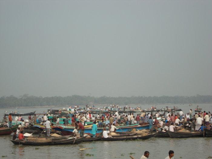
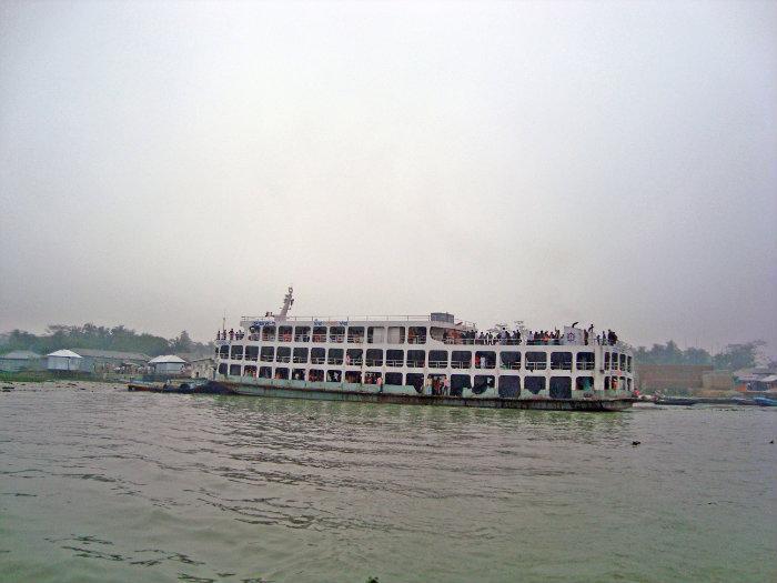
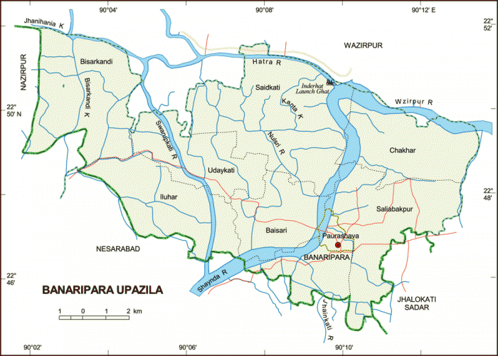

Banaripara Upazila (Barisal district) with an area of 134.32 sq km, is bounded by Wazirpur upazila on the north, Nesarabad (Swarupkati) upazila on the south, Wazirpur and Jhalokati sadar upazilas on the east, Nazirpur upazila on the west. Main rivers are Sandha, Swarupkati. Jhanihania and Bisarkandi Khals (canals) are notable.
The location of Banar4ipara town is 22.7808506N 90.1627411E. Banaripara (Town) The town is now a municipality with an area of the town is 4.77 sq km and Population: 14894 inhabitants (2001 Census); male 53.63.8%, female 46.37%. It has 9 wards and 16 mahallas. Literacy rate among the town people is 65.56%. It has one dakbungalow.
Banaripara thana was established in 1913 and was turned into an upazila in 1983. It consists of one municipality, 11 union parishads, 87 mouzas and 77 villages.
Population 143825; male 51%, female 49%; Muslim 82.55%; Hindu 16.75% and others 0.7%.
Literacy and educational institutions: Average literacy 46%; male 51.1%, female 49%. Educational institutions: government college 1, non-government college 2, high school 27, government primary school 80, non-government primary school 41, madrasa 59, deaf school 1, commercial school 1. Noted educational institutions: Government Fazlul Huq College (1940), Banaripara Union Institute (1889), Nalasree Government Primary School (1910).
Religious institutions: Mosque 265, temple 20, church 3, sacred place1, noted of which are Banaripara Jami Mosque, Binod Bihari Mandir.
Cultural organisations: Club 28, public library 1, cinema hall 1, circus party 1, theatre group 1, literary society 1, Nazrul Academy 1, playground 12.
Main occupations: Agriculture 27.28%, agricultural labourer 18.54%, wage labourer 4.78%, commerce 25.51%, service 7.91%, fishing 1.87%, transport 1.47%, construction 1.29%, others 11.35%.
Land use: Cultivable land 9983.81 hectares, fallow land 3247.33 hectares; single crop 59%, double crop 29% and treble crop land 12%. Cultivable land under irrigation 55%.
Land control: Among the peasants 29% are landless, 38% small, 9% rich.
Fisheries, dairies and poultries Poultry 140, dairy 30, fishery 60.
Communication facilities- Roads: pucca 23 km, semi pucca 39 km and mud road 427 km.
Manufactories: Rice mill 168, flour mill 6, ice factory 5, saw mill 8, pulse mill 6.
Cottage industries: Goldsmith 35, blacksmith 70, potteries 20, wood work 125, tailoring 215.
NGO activities: Operationally important NGOs are brac, CARE, asa, caritas, proshika, grameen bank, RDO, SDP, Jatiya Seba Sangstha.
Health centres: Upazila health complex 1, hospital 1, family planning centre 5, union satellite clinic 2, child health centre 1.
Nearby cities:
Coordinates: 22°47'0"N 90°9'32"E
- Lohajang Upazila 85 km
- Matlab Upazila (North) Area 91 km
- Keraniganj Upazila 108 km
- Rupganj Upazila 136 km
- Kapashia Upazila 169 km
- Patiya Upazila (পটিয়া) 175 km
- Banshkhali Upazila (বাঁশখালী উপজেলা) 186 km
- Chandanaish Upazila 192 km
- Gafargaon Upazila 198 km
- Dhobaura Upazila 269 km
- Greater Banaripara 4.9 km
- Sarsina Darbar Sharif 6.6 km
- HARTA BAZAR DRAWIN DY GOPAL SARKAR 10 km
- jamirbari bazaar 10 km
- AREA OF ZALLA 13 km
- Indurkani Village mark by Asim Barai(Wazirpur,Barisal) 15 km
- Kotwali Para 29 km
- Barishal Division 42 km
- Khulna Division 86 km
- Dhaka Division 152 km