Mount Labo
Philippines /
Bicol /
Tulay Na Lupa /
World
/ Philippines
/ Bicol
/ Tulay Na Lupa
World / Philippines / Camarines Norte / Labo
mountain, volcano
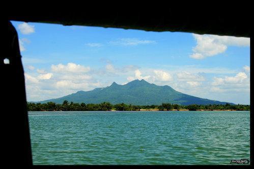
The tallest mountain in Camarines Norte. Mount Labo, is a potentially active stratovolcano in the province of Camarines Norte, in Region V, on Luzon Island, in the Philippines.
It is located at the northwest end of the Bicol Peninsular at latitude 14.02°N (14°1'0"N), longitude 122.792°E (122°47'30"E). Labo is a forested 1544 metre high andesitic stratovolcano, surrounded by numerous andesitic to dacitic satellite lava domes.
Labo has an elevation of 1544 metres asl.
Base diameter of this compound volcano is 35 kilometres.
Labo is thermally activity with both warm and hot springs.
Wikipedia article: http://en.wikipedia.org/wiki/Mount_Labo
Nearby cities:
Coordinates: 14°0'53"N 122°47'31"E
- Mt. Samat 40 km
- Mount Banahaw 148 km
- Talim Island 176 km
- Mount Makiling 177 km
- Taal Volcano 197 km
- Doña Remedios Trinidad 222 km
- Mt. Mingan Mountain Range 225 km
- Mount Disogsip 232 km
- Sierra Madre Mountains 250 km
- Mount Singyan 334 km
- Olivia Anatalio 6.2 km
- Hacienda Castillo 7.2 km
- Brgy. Napaod 7.7 km
- San Lorenzo Ruiz Town Proper 8.2 km
- Tulay na Lupa Proper 8.7 km
- Purok 6,Tulay na lupa 8.9 km
- Mabilo II 11 km
- Camarines Norte 14 km
- Camarines Sur 62 km
- Province of Quezon 83 km