Cannock
United Kingdom /
England /
Cannock /
World
/ United Kingdom
/ England
/ Cannock
World / United Kingdom / England
town
Add category

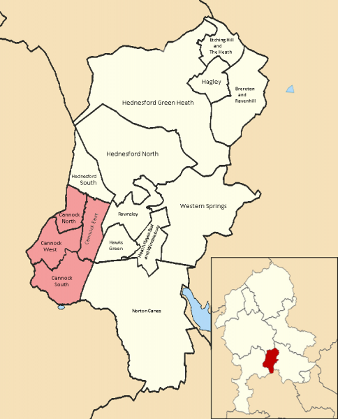
Cannock is the most populous of three towns in the district of Cannock Chase in the central southern part of the county of Staffordshire in the West Midlands region of England. It lies on the western border of the Cannock Chase district to the south and west of the Chase itself and comprises four electoral wards of the district council, namely Cannock Town north, south, east and west respectively (see outline map above). Included in the Cannock Town South ward area is the small county parish of Bridgtown which lies between the town centre and the M6 Motorway which runs along just to the south. To the north of the town and also in the Cannock Chase district is the separate town of Hednesford which is a continuation of the built up area.
Cannock lies to the north of the West Midlands conurbation on the M6, A34 and A5 roads, and to the south of Cannock Chase, an Area of Outstanding Natural Beauty (AONB). Cannock is served by a railway station on the Chase Line.Cannock had a 2010 mid-year estimated population of 27,883 (from the estimated headcounts of its four district council electoral wards). Cannock is also part of a wider built-up area which includes parts of South Staffordshire District. This is the Cannock urban subdivision of the Cannock/Great Wyrley Urban Area. Its population in the 2001 census was 65,022.
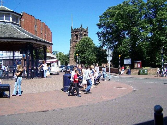
As important market centre for centuries, Cannock still attracts people from a wide area to its attractive central market place, supplemented by a modern precinct. Nearby St Luke's Church is Norman in origin but has been modified from the Middle Ages until the 1950s. Other interesting buildings include the impressive former council house overlooking an old bowling green and 18th-century waterworks.
for Cannock Chase D.C. profile on Cannock Town Centre character and historic suburbs see @:
www.cannockchasedc.gov.uk/downloads/file/2596/character...
for large-scale online map on Cannock Chase DC website showing electoral & parish ward boundaries (used in drawing attached polygon) see @:
mapping.cannockchasedc.com/readconditionsbeforeuse.htm
Cannock lies to the north of the West Midlands conurbation on the M6, A34 and A5 roads, and to the south of Cannock Chase, an Area of Outstanding Natural Beauty (AONB). Cannock is served by a railway station on the Chase Line.Cannock had a 2010 mid-year estimated population of 27,883 (from the estimated headcounts of its four district council electoral wards). Cannock is also part of a wider built-up area which includes parts of South Staffordshire District. This is the Cannock urban subdivision of the Cannock/Great Wyrley Urban Area. Its population in the 2001 census was 65,022.
As important market centre for centuries, Cannock still attracts people from a wide area to its attractive central market place, supplemented by a modern precinct. Nearby St Luke's Church is Norman in origin but has been modified from the Middle Ages until the 1950s. Other interesting buildings include the impressive former council house overlooking an old bowling green and 18th-century waterworks.
for Cannock Chase D.C. profile on Cannock Town Centre character and historic suburbs see @:
www.cannockchasedc.gov.uk/downloads/file/2596/character...
for large-scale online map on Cannock Chase DC website showing electoral & parish ward boundaries (used in drawing attached polygon) see @:
mapping.cannockchasedc.com/readconditionsbeforeuse.htm
Wikipedia article: http://en.wikipedia.org/wiki/Cannock
Nearby cities:
Coordinates: 52°41'31"N 2°1'46"W
- Walsall 5.6 km
- Sutton Coldfield 13 km
- Telford 36 km
- Leicester 55 km
- Nottingham 62 km
- Metropolitan Borough of Stockport 84 km
- Warrington 93 km
- Huddersfield 111 km
- Doncaster 111 km
- York 157 km
- Hatherton CP 3.3 km
- Great Wyrley CP 3.9 km
- Saredon CP 4.6 km
- Shareshill CP 5.2 km
- Essington Civil Parish 6.7 km
- Featherstone CP 7.1 km
- Penkridge CP 7.4 km
- Walsall (Metropolitan Borough of) 10 km
- Brewood and Coven CP 10 km
- South Staffordshire 13 km