Tisa Estuary
| river mouth
Serbia and Montenegro /
Vojvodina /
Titel /
World
/ Serbia and Montenegro
/ Vojvodina
/ Titel
, 7 km from center (Тител)
World / Serbia / Srednje-Banatski
river mouth
Add category
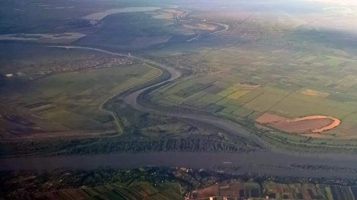

The Tisza or Tisa is one of the main rivers of Central Europe. It rises in Ukraine, and is formed near Rakhiv by the junction of headwaters White Tisa, whose source is in the Chornohora mountains and Black Tisa, which springs in the Gorgany range. It flows roughly along the Romanian border and enters Hungary at Tiszabecs; downstream, it marks the Slovak-Hungarian border, passes through Hungary, and falls into the Danube in central Vojvodina of Serbia.
Wikipedia article: http://en.wikipedia.org/wiki/Tisa
Nearby cities:
Coordinates: 45°8'31"N 20°16'18"E
- Nera River Delta 91 km
- Bunica and Buna Confluence 286 km
- River delta of Neretva 324 km
- Border zone 371 km
- Drin's Liman 378 km
- Estuary of Mat River 392 km
- Estuary of Shkumbin River 461 km
- Semedel channel 514 km
- Estuary of Isonzo river 530 km
- Regional Park of the Delta Po of Venice (VE) 629 km
- Slankamenska ada 1.4 km
- Titelska ada 5.3 km
- Surdukska ada 5.7 km
- Old delta of Tamis river 10 km
- Centa's Lake 11 km
- Dunavac Island 12 km
- Titelski Breg 13 km
- Municipality of Stara Pazova 19 km
- Palilula 27 km
- Municipality of Zrenjanin 27 km